Tropical Storm Auring weakens; wet weekend, Signal No. 1 in parts of Visayas, Mindanao
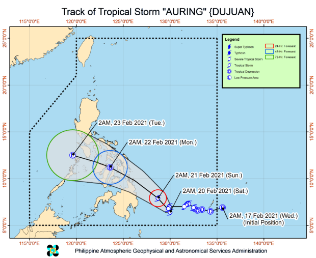
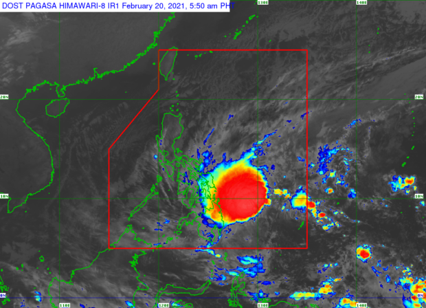
MANILA, Philippines — Tropical Storm Auring slightly weakened while almost stationary over Philippine Sea but will trigger moderate to heavy rains in parts of the Visayas and Mindanao on Saturday, the Philippine Atmospheric Geophysical and Astronomical Services Administration (Pagasa) said in its 5 a.m. weather bulletin.
Auring’s maximum sustained winds slowed down from 85 kilometers per hour (kph) near the center on Friday night to 75 kph with gustiness of from 105 kph to 90 kph, Pagasa said.
Auring was last spotted at 475 kilometers east southeast of Hinatuan, Surigao del Sur at 4 a.m., Pagasa added.
Pagasa said Auring will remain almost stationary in the next six to 12 hours before moving northwest.
Visayas, Mindanao rainfall forecast
Light to moderate with occasional heavy rains are expected over Eastern Visayas, Central Visayas, Caraga region, Davao Oriental, Davao de Oro, Davao del Norte, Bukidnon, Misamis Oriental, and Southern Leyte from Saturday morning until afternoon, Pagasa weather specialists said.
Heavy to intense rains will persist over Surigao del Norte, Surigao del Sur and Dinagat Islands.
The tropical storm will also bring moderate to intense rains over Misamis Oriental, Camiguin, and the rest of Caraga region.
Signal Number 1
Meanwhile, these following areas are still under Tropical Cyclone Wind Signal Signal No. 1 (30 to 60 kph winds expected in 36 hours)
Visayas
Northern Samar
Eastern Samar
Samar
Biliran
Leyte
Southern Leyte
Cebu
Negros Oriental
Bohol
Siquijor
Mindanao
Dinagat Islands
Surigao del Norte
Surigao del Sur
Agusan del Norte
Agusan del Sur
Davao Oriental
Davao de Oro
Davao del Norte
Davao City
Camiguin
Misamis Oriental
Misamis Occidental
Lanao del Norte
Bukidnon
Lanao del Sur
Sunday landfall forecast
“Its center is forecast to make landfall over the eastern coast of Caraga region on Sunday morning or afternoon, then cross Visayas and Mimaropa (Mindoro, Marinduque, Romblon, Palawan) throughout the remainder of Sunday through Monday,” state meteorologists said.
Auring will also remain as a tropical storm until it makes landfall.
“However, there is an increasing likelihood that the storm will weaken into a tropical depression before making landfall. Nevertheless, this storm will likely weaken considerably due to significant terrain interaction and persistent vertical wind shear during this passage over the archipelago and may reach tropical depression category on Monday,” said Pagasa.
READ: NDRRMC advisory: Brace for ‘Auring’ impact this weekend
gsg
Click here for more weather related news.
Disclaimer: The comments uploaded on this site do not necessarily represent or reflect the views of management and owner of Cebudailynews. We reserve the right to exclude comments that we deem to be inconsistent with our editorial standards.