‘Dante’ intensifies into tropical storm; another LPA spotted outside PAR – Pagasa
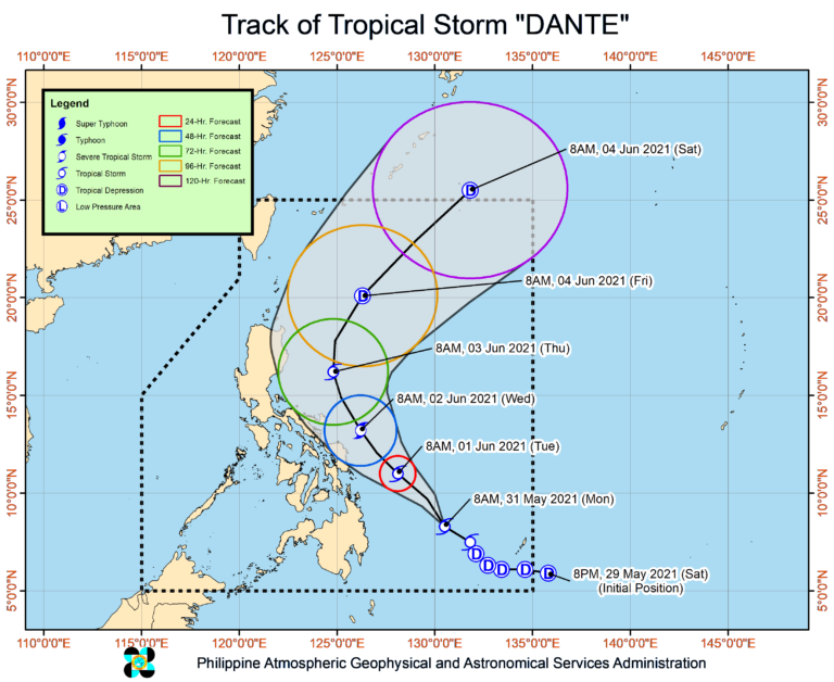
Tropical Storm Dante’s track
MANILA, Philippines — Tropical depression Dante has strengthened into a tropical storm (international name: Choi-Wan) on Monday morning as it floats over the Philippine Sea, according to the state weather service.
This comes as the Philippine Atmospheric, Geophysical, and Astronomical Services Administration (Pagasa) spotted another low-pressure area outside the Philippine Area of Responsibility (PAR) – some 1,800 kilometers east of Mindanao.
Senior Weather Specialist Chris Perez said Dante was located 515 kilometers east northeast of Davao City and 445 km east of Hinatuan, Surigao del Sur, as of 10 a.m., packing maximum sustained winds of up to 75 kilometers per hour (kph) and gustiness of up to 90 kph. It was moving northwest at a speed of 20 kph.
“Bagamat nasa karagatan pa rin ‘yung tinataya nitong sentro, mapapansin natin na talagang ‘yung outer rainbands nito ay nakakaapekto na nga sa Mindanao at maging sa ilang bahagi ng Visayas particular na po sa eastern at central Visayas,” Perez said.
(Although the estimated eye of the storm is still in the ocean, we can notice that its outer rainbands are already affecting Mindanao and even some parts of the Visayas, particularly in the eastern and central Visayas.)
“Inaasahan natin na makakaranas ang mga nabanggit na lugar ng maulap na kalangitan at kalat kalat na pagulan at pagkidlat at pagkulob sa araw na ito,” he added.
(We expect the aforementioned areas to experience cloudy skies, scattered rain, lightning, and thunder today.)
He continued that Dante’s outer rainbands will continue to bring rain to Caraga, the Davao Region, Soccsksargen, Bukidnon, and Misamis Oriental.
Scattered Floods, flash floods, and landslides due to rain are possible in these areas, according to Perez.
Earlier projections of Pagasa that Dante is not expected to hit land stays, as it will most likely just remain over the Philippine Sea throughout the forecast period.
Because of this, Pagasa has so far not raised any tropical cyclone wind signals (TCWS) in the country.
“However, any further westward shift in the track forecast may lead to the hoisting of TCWS over the eastern portion of the country,” said Perez.
According to Pagasa, Dante may reach severe tropical storm category by Wednesday “before weakening throughout the forecast period.”
The new low-pressure area outside PAR, meanwhile, has no effect yet on the country’s climate, Pagasa said.
“Wala pa itong direktang epekto sa ating bansa at maliit pa ang tiyansa nito maging bagyo (It has not yet had a direct impact on our country and there is still little chance of it becoming a storm),” Perez noted.
Disclaimer: The comments uploaded on this site do not necessarily represent or reflect the views of management and owner of Cebudailynews. We reserve the right to exclude comments that we deem to be inconsistent with our editorial standards.