Signal No. 1 raised over several Isabela, Aurora towns as ‘Karding’ maintains strength

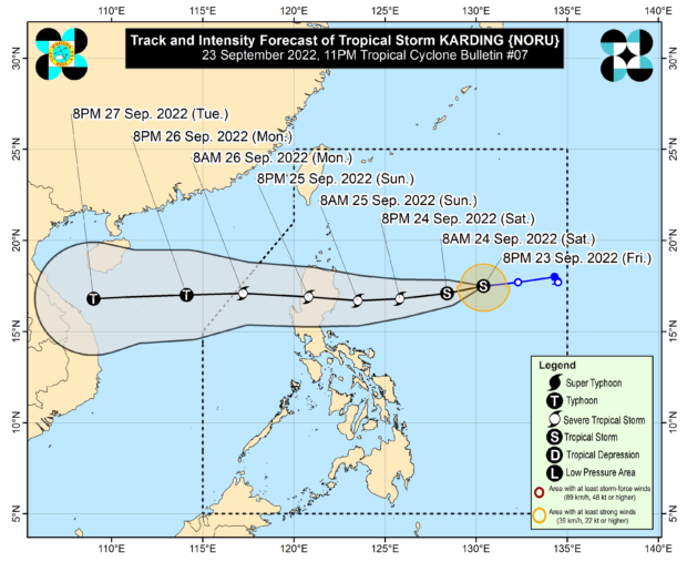
Track of TS Karding as of 11PM, Sept. 23. Image from Pagasa.
MANILA, Philippines — Tropical Storm Karding maintained its strength as it nears the Luzon landmass, prompting the Philippine Atmospheric, Geophysical and Astronomical Services Administration (Pagasa) to raise Tropical Cyclone Wind Signal No. 1 over several towns of Isabela and Aurora.
Pagasa’s latest update on Friday night said Signal No. 1 is already hosted over the following areas:
- eastern portion of Isabela (Divilacan, Palanan, Dinapigue, Maconacon, San Mariano, Ilagan City)
- northern portion of Aurora (Casiguran, Dilasag, Dinalungan)
According to Pagasa, Karding was last seen 895 kilometers east of Northern Luzon, still packing maximum sustained winds of 75 kilometers per hour (kph) near the center and gustiness of up to 90 kph.
It is also still moving west at a speed of 15 kph.
As of now, Pagasa’s forecasts maintained that Karding will intensify into a severe tropical storm by Saturday night, at which time it would be 395 kilometers east of Casiguran.
By Sunday morning, it would be just 155 kilometers northeast of Casiguran, with Karding now packing maximum sustained winds of 110 kph.
It would then cross Luzon, weakening slightly due to the mountain ranges. By Sunday night it would over the vicinity of Mankayan, Benguet, before emerging towards the West Philippines Sea.
Karding would then leave the Philippine area of responsibility between Monday afternoon and night. However, before Karding leaves, Pagasa said there is a possibility that Signal No. 3 and Signal No. 4 would be raised if the cyclone intensified further into a typhoon-category.
Pagasa said that from Saturday night to Sunday early morning, light to moderate with at times heavy rains will be felt over Batanes, Cagayan, Isabela, and the northern portion of Aurora.
From Sunday through Monday, heavy to intense rains would affect the northern portion of Aurora, Isabela, Quirino, Nueva Vizcaya, Benguet, La Union, and Pangasinan.
Meanwhile, moderate to heavy rains with at times intense rains will prevail over mainland Cagayan, Ilocos Provinces, Nueva Ecija, Tarlac, the northern portion of Zambales, and the rest of Cordillera Administrative Region. Light to moderate with at times heavy rains will be felt over the rest of Cagayan Valley and Central Luzon.
Pagasa warned that these conditions may cause flash floods, scattered flooding, and landslides over areas near mountain slopes.
It also noted that the cyclone would intensify the southwest monsoon or habagat, and would bring occasional rains over most of Southern Luzon, including Metro Manila, and parts of Visayas.
RELATED STORIES
Pagasa: ‘Nanmadol’ intensifies into severe tropical storm outside PAR
Inday now a typhoon, may enhance southwest monsoon
Disclaimer: The comments uploaded on this site do not necessarily represent or reflect the views of management and owner of Cebudailynews. We reserve the right to exclude comments that we deem to be inconsistent with our editorial standards.
