Super typhoon Mawar slightly intensifies, to enter PH as Betty

| Pagasa satellite image
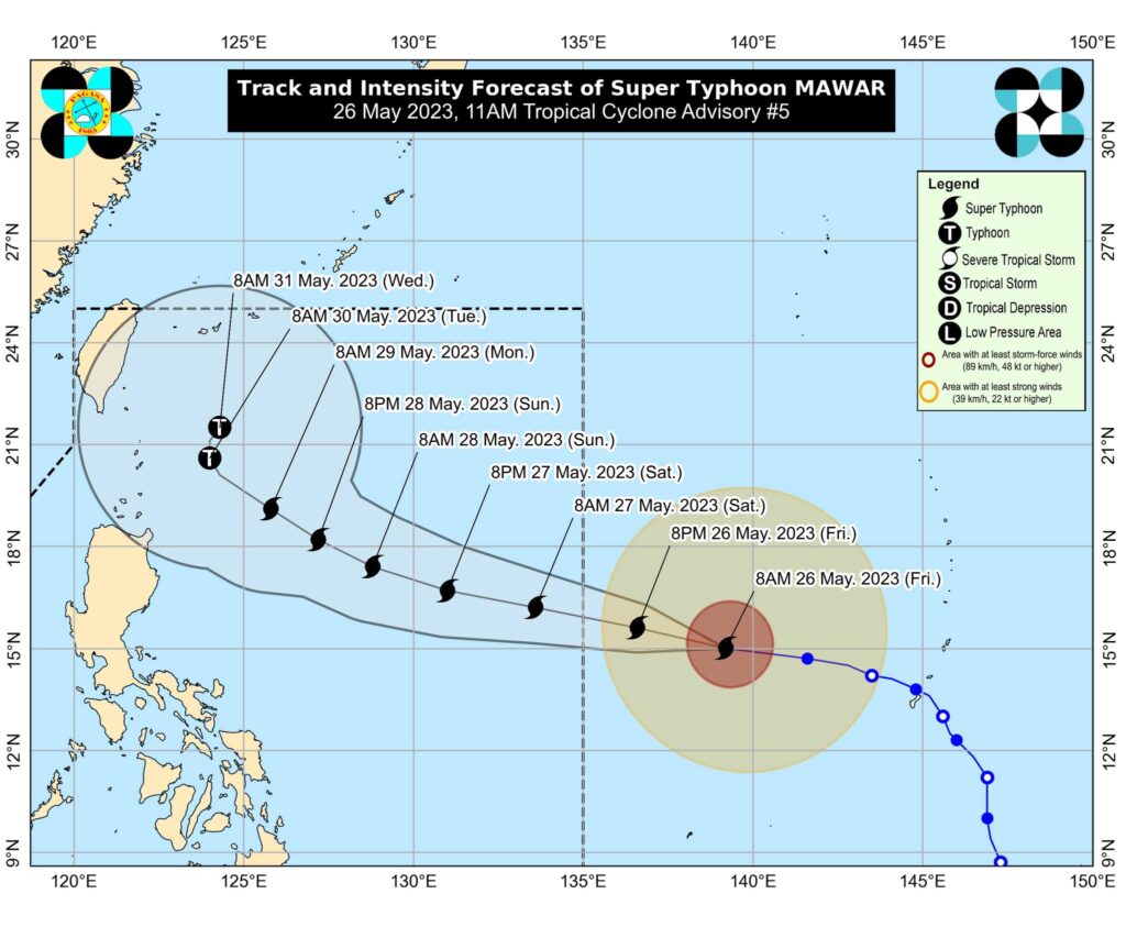
CEBU CITY, Philippines—Super typhoon Mawar has slightly intensified as it moves westward over the Philippine sea, Pagasa said in its latest advisory released 11 a.m. Friday, May 26, 2023.
The advisory said the center of the eye of super typhoon Mawar is now 1,705 kilometers (km) east of southeastern Luzon, bringing maximum sustained winds of 215 km/hour (km/h) near the center, gustiness of up to 260 km/h, and central pressure of 905 hPa.
It is moving west at 20 km/h.
READ MORE: Super Typhoon Mawar further intensifies; may reach peak force in 24-36 hrs – Pagasa
Strong to typhoon-force winds extend outwards up to 550 km from the center of the storm.
Super Typhoon MAWAR is forecast to track generally west northwestward until Sunday while accelerating before turning northwestward on Sunday, Pagasa said.
Super Typhoon Betty
The super typhoon is expected to enter the Philippine Area of Responsibility (PAR) Friday night or Saturday early morning. Once it does, it will be called super typhoon Betty.
the super typhoon will begin to decelerate on Sunday as it begins to move closer towards the waters east of extreme northern Luzon.
The center of MAWAR’s eye is forecast to be within 250 km of the Batanes-Babuyan archipelago by next week during the slowdown period.
READ MORE: Most of Guam without power, water after Super Typhoon Mawar exits
The Pagasa advisory also said the super typhoon may slightly weaken by Saturday evening but is expected to remain as a super typhoon until Monday morning due to highly favorable environment.
| pagasa image
Mawar will then weaken at a slightly faster rate by late Monday or Tuesday as unfavorable conditions, such as increasing wind shear, cooler sea surface temperature resulting from its slowdown by that time, dry air intrusion, take place.
READ MORE: #WalayKlase: Class suspensions in Cebu as of May 26, 2023 due to Super Typhoon Mawar
Current forecast scenario shows that the typhoon may bring heavy rains over northern Luzon beginning late Sunday or on Monday next week.
Mawar is also forecast to enhance the southwest monsoon, which may bring monsoon rains over the western portions of central Luzon, southern Luzon, and Visayas beginning on Sunday or Monday.
Disclaimer: The comments uploaded on this site do not necessarily represent or reflect the views of management and owner of Cebudailynews. We reserve the right to exclude comments that we deem to be inconsistent with our editorial standards.