New LPA may enter PAR July 29 and develop into tropical depression – Pagasa
Another LPA is spotted that is expected to enter the Philippine Area of Responsibility by Saturday, July 29.
MANILA, Philippines —Brace for more bad weather.
Another storm is on the horizon, threatening the Philippines just as Typhoon Egay is exiting.
The state weather bureau said Thursday that the new low-pressure area (LPA) it is monitoring has a high chance of developing into a tropical depression for the next two days. It may enter the Philippine area of responsibility (PAR) by Saturday, July 29.
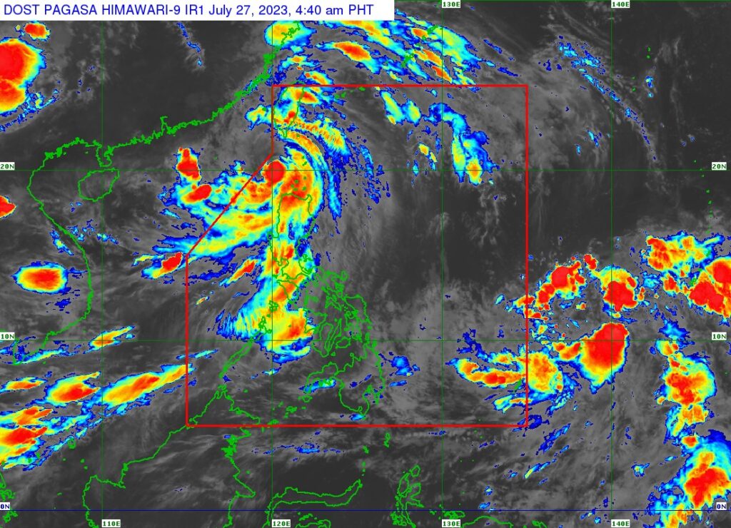
State weather specialist Benison Estareja said in a public forecast that the LPA has no direct impact yet on the country since it is still outside PAR – 1,800 kilometers east of northeastern Mindanao – as of early morning on Thursday.
Earlier in the day, INQUIRER.net reported that the Philippine Atmospheric, Geophysical and Astronomical Services Administration (Pagasa) had lifted Tropical Cyclone Wind Signal (TCWS) No. 3 as it expected the weakening Typhoon Egay (international name: Doksuri) to leave PAR within today, July 27.
Egay may further reduce strength as it moves west of Batanes at 15 kilometers per hour (kph). The typhoon was last located 195 kilometers west of Basco, Batanes, packing maximum sustained winds of 150 kph near the center and up to 180 kph gustiness.
As Egay departs, Pagasa said once the new LPA enters PAR and becomes a tropical depression, it will be named Falcon, according to Estareja. Falcon might be the sixth tropical cyclone to hit the country this year, and the third this July.
Still, the LPA is expected to whip up the prevailing southwest monsoon, locally called habagat, which will dump rain in several parts of the country.
“Malayo pa ito sa ating bansa at wala pa pong direktang epekto, pero asahan po natin hanggang sa unang araw ng Agosto ay magdadala pa rin ito ng ulan dulot ng habagat na siyang palalakasin nito sa mga susunod na araw,” weather specialist Benison Estareja said in a morning briefing.
(It is still far from our country and has no direct impact yet, but let’s expect until the first day of August that it will still bring rain due to the south wind, which will strengthen it in the following days.)
“Habang nasa labas ito ng PAR for the next two days mataas ang tsansa na ito ay maging isang bagyo or tropical depression,” he added.
(While it is outside the PAR for the next two days, there is a high chance it will become a typhoon or tropical depression.)
The LPA is predicted to cross the Philippine Sea until Tuesday (August 1) next week while moving generally northwestward, far from the country’s landmass, Estareja noted, adding that the weather disturbance will likely leave the PAR by Tuesday or Wednesday.
READ MORE:
‘Egay’ weakens over Luzon strait
Disclaimer: The comments uploaded on this site do not necessarily represent or reflect the views of management and owner of Cebudailynews. We reserve the right to exclude comments that we deem to be inconsistent with our editorial standards.