LPA develops into Tropical Depression Julian – Pagasa

Pagasa Julian storm track
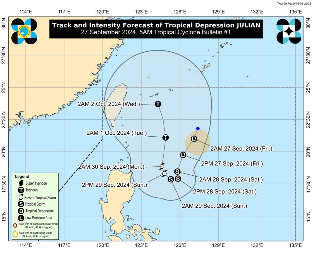
MANDAUE CITY, Philippines — The low pressure area east of Batanes has developed into Tropical Depression “Julian,” which may possibly become a typhoon by Monday or Tuesday. That is according to the state weather bureau in its 5 a.m. weather advisory, today, September 27.
Based on its latest weather advisory, the Philippine Atmospheric Geophysical Astronomical Services Administration (Pagasa) said that Julian would be expected to intensify in the next few days and would be expected to reach tropical storm category by tonight or tomorrow morning.
READ MORE:
EXPLAINER: What do color-coded rainfall warnings mean?
LPA off northern Luzon may become storm
According to Pagasa, Julian is forecast to follow a looping path over the waters east of Batanes and Cagayan in the next five days.
Initially, the tropical cyclone will head south southwestward today while decelerating, then move slowly westward tomorrow (September 28) and northwestward on Sunday (September 29), before accelerating generally northward on Monday (September 30) and Tuesday (October 1)
“Manatili sa PAR sa may North Philippine Sea itong Tropical Depression Julian sa susunod ng at least limang araw,” said Benison Estareja, weather specialist of Pagasa in its 5 a.m. weather report, based on the latest track of Pagasa.
(Tropical Depression Julian will stay in PAR in the North Philippine Sea in at least five days.)
“Ibig sabihin, ngayon hanggang sa Sunday kikilos patimog itong nasabing bagyong Julian at maaring 300 to 400 kilometers silangan ng Cagayan Valley. Pagsapit naman ng Sunday hanggang sa Wednesday, ay kikilos na pahilaga itong nasabing bagyo habang nasa may silangan pa man ng Cagayan Valley around 300 kilometers away,” said Estareja.
(This means that now until Sunday, storm Julian will move south and this may be around 300 to 400 kilometers south of Cagayan Valley. On Sunday until Wednesday, this will move west while it is in the south of Cagayan Valley still at around 300 kilometers away.)
“At base pa rin sa atong track, posible pa ring lumakas pa ito as a tropical depression for today. Possible pa ring in the next 24 hours lumakas pa si tropical storm at hindi rin natin inalis ang tsansa na lalakas pa ito as a typhoon pagsapit ng Monday or Tuesday,” he said.
(And based on the (storm Julian) track (of Pagasa), it is possible that this will intensify as a tropical depression today. It is also possible that in the next 24 hours, the tropical storm will intensify and we are not removing the chance that it will further intensify into a typhoon on Monday or Tuesday.)
Pagasa also advised the the public and disaster risk reduction and management offices concerned to take all necessary measures to protect life and property.
Persons living in areas identified to be highly or very highly susceptible to these hazards are advised to follow evacuation and other instructions from local officials.
The state weather bureau also advised the public to monitor the weather information in their specific areas through advisories from Pagasa.
Julian is the 10th storm of the year and the sixth one for the month of September, said weather specialist Estareja.
Disclaimer: The comments uploaded on this site do not necessarily represent or reflect the views of management and owner of Cebudailynews. We reserve the right to exclude comments that we deem to be inconsistent with our editorial standards.
