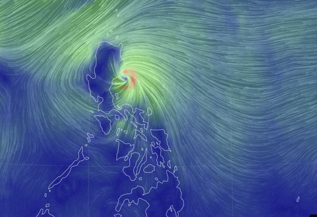
Nika intensifies into typhoon; Signal no. 4 raised in several areas

image from earth.nullschool
Nika (International name: Toraji) has intensified into a typhoon, Pagasa said in its early Monday morning (November 11, 2024) weather update.
Based on its 5 a.m. bulletin, Pagasa said the center of Nika was at 100 kilometers east southeast of Casiguran, Aurora, bringing maximum sustained winds of 120 km/h near the center.
READ MORE:
Nika update: Classes suspended on Monday in several Luzon areas
LIST: Philippine Typhoon Names for 2024
Nika is moving west northwestward at 20 km/h, packing strong to typhoon-force winds that extend outwards up to 340 km from the center, the Pagasa bulletin said.
NIKA: TROPICAL CYCLONE WIND SIGNALS (TCWS) IN EFFECT
Signal No. 4
LUZON:
The northernmost portion of Aurora (Dilasag, Casiguran), the central and southern portions of Isabela (Dinapigue, San Mariano, San Guillermo, Jones, Echague, Ramon, San Isidro, City of Santiago, Cordon, Roxas, Burgos, Reina Mercedes, Naguilian, Benito Soliven, Gamu, San Manuel, Aurora, San Mateo, Cabatuan, Alicia, Luna, City of Cauayan, Angadanan, Quezon, Mallig, Quirino, Ilagan City, Delfin Albano, San Agustin), the southeastern portion of Abra (Tubo, Boliney, Daguioman, Bucloc, Malibcong), the central and eastern portions of Mountain Province (Sadanga, Bontoc, Barlig, Natonin, Paracelis), the eastern portion of Ifugao (Aguinaldo, Mayoyao, Alfonso Lista), and the western and southern portions of Kalinga (Tanudan, Tinglayan, Pasil, Lubuagan, Balbalan, City of Tabuk)
Signal No. 3
LUZON:
The northern portion of Aurora (Dinalungan), the northeastern portion of Nueva Vizcaya (Diadi, Bagabag, Quezon, Solano, Villaverde, Kasibu, Ambaguio, Bayombong), the northern portion of Quirino (Diffun, Cabarroguis, Aglipay, Saguday, Maddela), the rest of Isabela, the southwestern portion of Cagayan (Enrile, Solana, Tuao, Tuguegarao City, Rizal, Piat), the rest of Abra, the southern portion of Apayao (Conner, Kabugao), the rest of Kalinga, the rest of Mountain Province, the rest of Ifugao, the northern portion of Benguet (Buguias, Mankayan, Bakun), the southern portion of Ilocos Norte (Laoag City, Sarrat, San Nicolas, Piddig, Marcos, Nueva Era, Dingras, Bacarra, Solsona, Paoay, Currimao, Pinili, Badoc, City of Batac, Banna), and Ilocos Sur
Signal No. 2
LUZON:
The central portion of Aurora (Dipaculao, Maria Aurora, Baler), the rest of Nueva Vizcaya, the rest of Quirino, the northwestern and eastern portions of Cagayan (Iguig, Peñablanca, Baggao, Alcala, Amulung, Santo Niño, Gattaran, Lasam, Santa Praxedes, Claveria, Sanchez-Mira, Pamplona, Abulug, Allacapan, Ballesteros, Lal-Lo, Aparri, Camalaniugan, Buguey, Santa Teresita, Gonzaga), the rest of Apayao, the rest of Benguet, the rest of Ilocos Norte, La Union, the northeastern portion of Pangasinan (San Nicolas, Natividad, San Quintin, Sison, San Manuel, Umingan, Tayug), and the northern portion of Nueva Ecija (Carranglan, Pantabangan, Lupao, San Jose City)
Signal No. 1
LUZON:
The rest of Aurora, the rest of Cagayan including Babuyan Islands, the rest of Pangasinan, the rest of Nueva Ecija, Bulacan, Pampanga, Tarlac, the northern and central portions of Zambales (Santa Cruz, Candelaria, Masinloc, Palauig, Iba, Botolan, Cabangan, San Marcelino, San Felipe, San Narciso), Metro Manila, Rizal, the eastern portion of Laguna (Santa Maria, Mabitac, Pakil, Pangil, Famy, Siniloan, Paete, Kalayaan, Cavinti, Lumban, Luisiana, Santa Cruz, Magdalena, Pagsanjan, Majayjay, Liliw, Nagcarlan, Pila, Victoria), the northern and eastern portions of Quezon (Calauag, Infanta, Quezon, Alabat, Sampaloc, Mauban, Perez, Real, General Nakar, Tagkawayan, Guinayangan) including Pollilo Islands, Camarines Norte, and the northeastern portion of Camarines Sur (Siruma, Tinambac, Garchitorena, Lagonoy)
NIKA: TRACK AND INTENSITY OUTLOOK
According to Pagasa, NIKA is forecast to move generally west northwestward until Thursday, November 14, before turning generally southwestward on Friday.
On the track forecast, Nika may make landfall over Isabela or northern Aurora on Monday morning.
NIKA may further intensify over the next hours prior to landfall. It may weaken into a severe tropical storm while traversing mainland Luzon due to land interaction, Pagasa said.
Monitoring Ofel
Meanwhile, the low pressure area outside of the Philippine Area of Responsibility (PAR) has developed into a tropical depression.
As of 4 a.m. on Monday, Pagasa said the tropical depression was at 1,620 km east of eastern Visayas.
The Tropical Depression (TD) will steadily move west northwestward and may enter the PAR Tuesday morning, November 12, as Tropical Cyclone OFEL.
It will continue to move west northwestward while over Philippine Sea east of Luzon.
Disclaimer: The comments uploaded on this site do not necessarily represent or reflect the views of management and owner of Cebudailynews. We reserve the right to exclude comments that we deem to be inconsistent with our editorial standards.
