Pagasa: Fair Thursday weather in most parts of PH even as ‘Inday’ enters PAR
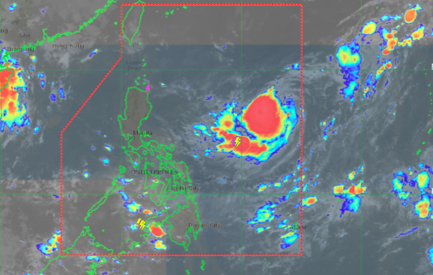
Pagasa satellite image as of 7:25 a.m.
MANILA, Philippines — Fair weather will prevail in Metro Manila and other parts of Luzon and the Visayas on Thursday, despite the entry of Tropical Storm Inday into the Philippine area of responsibility (PAR), according to the state weather bureau.
The Philippine Atmospheric, Geophysical and Astronomical Services Administration (Pagasa), in its early morning update, reported that “Inday” is not expected to have a direct impact on the country other than possibly enhancing the southwest monsoon or “habagat.”
“Base po sa ating latest satellite animation, wala pong direct effect itong si Bagyong Inday dito sa malaking bahagi ng bansa, and in fact, malaking bahagi ng Luzon and Visayas ay makakaranas ng maaraw na panahon, na sasamahan lamang ng localized thunderstorms na walang kinalaman kay Inday,” said Pagasa weather specialist Benison Estreja.
(Based on our latest satellite animation, Tropical Storm Inday will have no direct effect on a large part of the country, and in fact, a large part of Luzon and Visayas will experience fair weather conditions, with possible localized thunderstorms that have nothing to do with Inday).
Estreja, however, said that Inday may gain strength and be upgraded to a Severe Tropical Storm or even Typhoon category by weekend. Inday is expected to leave the PAR by Monday or Tuesday.
Estareja added that as of 5:00 a.m. Thursday, “Inday” was spotted some 1, 200 kilometers east of Central Luzon with maximum sustained winds of 75 kilometers per hour (kph) near the center and gustiness of of to 90 kph.
It is moving west at 15 kph.
Cloudy skies with scattered rain showers and thunderstorms are expected due to the intertropical convergence zone in Western Visayas, Zamboanga Peninsula, Northern Mindanao, and BARMM. For areas affected by rainfall, Pagasa warned of possible flash floods and landslides.
The state weather bureau did not raise any gale warnings for Thursday.
Forecast temperature range in key cities on Thursday:
- Metro Manila — 25 to 34 degrees Celsius
- Baguio — 17 to 24 degrees Celsius
- Laoag — 25 to 32 degrees Celsius
- Tuguegarao — 25 to 35 degrees Celsius
- Legazpi — 26 to 33 degrees Celsius
- Puerto Princesa — 26 to 32 degrees Celsius
- Tagaytay — 23 to 31 degrees Celsius
- Kalayaan Islands — 26 to 33 degrees Celsius
- Iloilo — 25 to 32 degrees Celsius
- Cebu — 25 to 32 degrees Celsius
- Tacloban — 26 to 33 degrees Celsius
- Cagayan de Oro — 24 to 30 degrees Celsius
- Zamboanga — 24 to 33 degrees Celsius
- Davao — 25 to 32 degrees Celsius
gsg
Click here for more weather related news.
Disclaimer: The comments uploaded on this site do not necessarily represent or reflect the views of management and owner of Cebudailynews. We reserve the right to exclude comments that we deem to be inconsistent with our editorial standards.