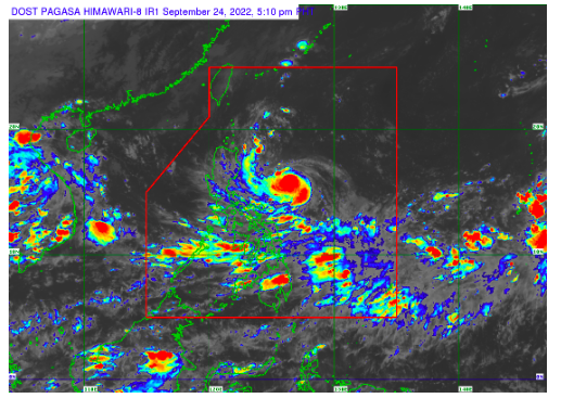
Severe Tropical Storm Karding intensifies; Signal No.2 up in 8 more areas

MANILA, Philippines — The state weather bureau raised Tropical Cyclone Wind Warning Signal (TCWS) No. 2 in eight more areas after Severe Tropical Storm Karding (international name: Noru) further intensified as it moves to make landfall in the country.
According to the Philippine Atmospheric Geophysical and Astronomical Services Administration (Pagasa), Karding was last located 475 kilometers (kms) East of Casiguran, Aurora or 520 kms East of Baler, Aurora.
It carries maximum sustained winds of 110 kms per hour (kps) near the center and gustiness of up to 135 kph as it moves west southwestward at 135 kph.
“This tropical cyclone is forecast to intensify into a typhoon in the next 12 hours and may further intensify prior to landfall,” said Pagasa in its latest typhoon bulletin.
The weather bureau then said that Karding is expected to make landfall on Sunday afternoon.
Pagasa said light to moderate with at times heavy rain are forecast in Batanes, Cagayan, Isabela, the northern portion of Aurora, Catanduanes, Camarines Norte, and Camarines Sur until Sunday morning.
Meanwhile heavy to intense with at times torrential rains are expected from Sunday to Monday over Aurora, Nueva Ecija, Tarlac, Pangasinan, and the northern portion of Zambales, while moderate to heavy with at times intense are likely over the rest of Central Luzon.
Moderate to heavy rains, on the other hand, should be expected over Cagayan, Isabela, Quirino, Nueva Vizcaya, Cordillera Administrative Region, Ilocos Provinces, La Union, Metro Manila, and Calabarzon.
Signal No. 2 (gale-force winds prevailing or expected within the next 24 hours) is up over the following areas:
- The southeastern portion of Isabela (Dinapigue, Jones, San Agustin, Echague, San Guillermo, San Mariano)
- Southeastern portion of Quirino (Nagtipunan, Maddela)
- Southeastern portion of Nueva Vizcaya (Alfonso Castaneda)
- Eastern portion of Nueva Ecija (Bongabon, Laur, Palayan City, General Tinio, Gabaldon, Pantabangan, Rizal)
- Aurora
- Eastern portion of Bulacan (Doña Remedios Trinidad, Norzagaray)
- Eastern portion of Rizal (Rodriguez, Antipolo City, Tanay)
- Eastern portion of Laguna (Santa Maria, Famy, Siniloan, Pangil, Pakil, Paete, Kalayaan, Lumban, Cavinti)
- Northern and central portion of Quezon (General Nakar, Pollilo Islands, Infanta, Real, Mauban, Perez, Alabat, Quezon, Calauag, Tagkawayan, Guinayangan)
- Northwestern portion of Camarines Sur (Del Gallego, Ragay, Lupi, Sipocot)
- Camarines Norte
Signal No. 1 (strong winds prevailing or expected within the next 36 hours) was raised over the following areas:
- The southern portion of Cagayan (Peñablanca, Iguig, Tuguegarao City, Enrile, Solana, Tuao, Piat, Amulung, Rizal)
- Rest of Isabela
- Rest of Quirino
- Rest of Nueva Vizcaya
- Southern portion of Apayao (Conner)
- Abra
- Kalinga
- Mountain Province
- Ifugao
- Benguet
- Southern portion of Ilocos Norte (Nueva Era, Badoc, Pinili, Banna, City of Batac, Currimao, Paoay, Marcos)
- Ilocos Sur
- La Union
- Pangasinan
- Rest of Nueva Ecija
- Rest of Bulacan
- Tarlac
- Pampanga
- Zambales
- Bataan
- Metro Manila
- Rest of Laguna
- Rest of Rizal
- Rest of Quezon
- Cavite
- Batangas
- Rest of Camarines Sur
- Albay
- Catanduanes
- Marinduque
- Northwestern portion of Occidental Mindoro (Lubang Islands, Paluan, Abra de Ilog)
and the northewestern portion of Oriental Mindoro (San Teodoro, Puerto Galera, City of Calapan, Baco)
RELATED STORIES:
NDRRMC on red alert for Severe Tropical Storm Karding
Red alert status up in Cagayan Valley as ‘Karding’ threatens Northern Luzon
Click here for more weather related news.
Disclaimer: The comments uploaded on this site do not necessarily represent or reflect the views of management and owner of Cebudailynews. We reserve the right to exclude comments that we deem to be inconsistent with our editorial standards.
