
Live updates on Typhoon Hanna, which has an international name, Haikui. (Updated September 4, Monday, 2:02 p.m.)
HANNA LEAVES PAR; BATANES WIND SIGNAL LIFTED
Typhoon Hanna (international name: Haikui) has exited the Philippine area of responsibility (PAR) but will still enhance the southwest monsoon, the state weather agency said Monday.
According to the Philippine Atmospheric, Geophysical and Astronomical Services Administration’s (Pagasa) advisory posted at 8:43 a.m. on Facebook, Hanna left PAR at 8 a.m. In its final cyclone bulletin issued at 11 a.m., September 4, Pagasa lifted the wind signal raised over Batanes.
Hanna made its second landfall in Taiwan’s Kaohsiung City at 4 a.m. on Monday. Pagasa said in its 11 a.m. update that the typhoon was already 360 kilometers northwest of Itbayat, Batanes, packing maximum sustained winds of 120 kilometers per hour (kph) near the center with gusts of up to 165 kph. It was moving north-northwestward at 15 kph.
Pagasa: Typhoon Hanna behaves erratically off the coast of southwestern Taiwan
Typhoon Hanna is behaving eratically off the coast of southwestern Taiwan as it makes landfall in Kaohsiung City on Monday morning, September 4, 2023, Pagasa said in its 5 a.m. bulletin.
The state weather bureau said the center of the eye of Typhoon Hanna was estimated at 265 kilometers northwest of Itbayat, Batanes or in the vicinity of Kaohsiung City, Taiwan at 4 a.m.
It has maximum sustained winds of 120 km/h near the center, gustiness of up to 165 km/h, and central pressure of 975 hPa.
HANNA MAKES LANDFALL IN TAIWAN
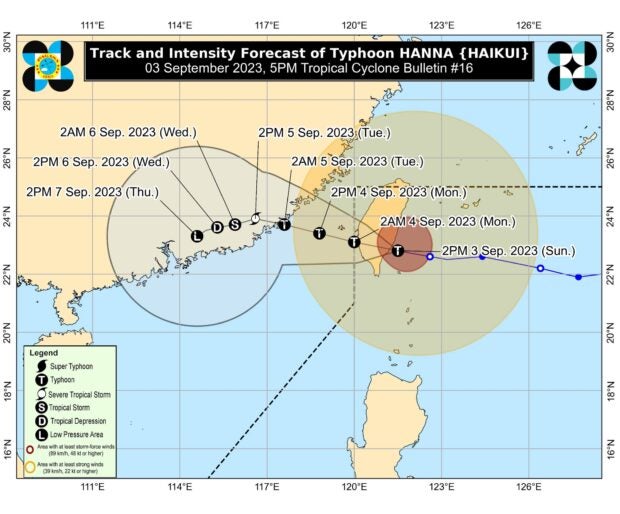
Track of Typhoon Hanna, with international name is Haikui, as it exits the Philippine area of responsibility. Image from Pagasa
Typhoon Hanna (international name: Haikui) made landfall in Taitung County, Taiwan, around 2 p.m. on Sunday, according to the Philippine Atmospheric, Geophysical and Astronomical Services Administration (Pagasa).
In its 5 p.m. cyclone update, the state weather bureau reported that Hanna slightly accelerated from 10 kilometers per hour (kph) to 20 kph as it moved west-northwestward. It carries maximum sustained winds of 155 kph with gusts of up to 255 kph.
Although the typhoon is forecast to exit the Philippine area of responsibility (PAR) by tonight or Monday morning, wind signals remained hoisted in Batanes and Babuyan Islands, which will likely experience heavy rainfall for the rest of the day.
TYPHOON HANNA SLIGHTLY INTENSIFIES
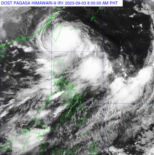
Typhoon Hanna, whose international name is Haikui. Photo from Pagasa
Typhoon Hanna (international name: Haikui) slightly strengthened as it moves closer to Southern Taiwan’s coast early Sunday morning, September 3.
Based on the 5 a.m., September 3 bulletin of the Philippine Atmospheric, Geophysical and Astronomical Services Administration (Pagasa), Batanes and the northern portion of Babuyan Islands, particularly Babuyan Island and Calayan Island, remain under Tropical Cyclone Wind Signal No. 1 as Hanna intesified.
Hanna’s eye was last located 215 kilometers north-northeast of Itbayat, Batanes, packing maximum sustained winds of 150 kilometers per hour (kph) with gustiness of up to 185 kph. It was moving westward at 20 kph.
TYPHOON HANNA: SIGNAL NO. 1 UP IN BATANES
The Philippine Atmospheric, Geophysical and Astronomical Services Administration (Pagasa) raised Tropical Cyclone Wind Signal No. 1 in Batanes on Saturday.
This is due to the effects of Typhoon Hanna (international name: Haikui), and the outer rainbands of Typhoon Goring (international name: Saola) which is already outside the Philippine area of responsibility (PAR).
According to Pagasa, Hanna is expected to exit the PAR on Monday afternoon or evening.
‘HANNA’ INTENSIFIES
Severe tropical storm “Hanna” decelerates as it moves westward over the Philippine Sea, based on the 11 a.m. advisory of Pagasa.
Moving 10 kilometers per hour (km/h) westward, Hanna brings maximum sustained winds of 110 km/h near the center, gustiness of up to 135 km/h, and central pressure of 985 hPa.
The center of the storm is 1,160 km east of extreme northern Luzon.
——
‘HANNA’ MAINTAINS STRENGTH
Based on the 5 a.m. bulletin of Pagasa, severe tropical storm #HannaPH was moving west northward over the Philippine Sea.
The location of the center was at 1,225 kilometers east of extreme northern Luzon, bringing maximum sustained winds of 95 km/h near the center, gustiness of up to 115 km/h, and central pressure of 990 hPa.
It was moving west northwestward at 20 km/h.
READ MORE:
Subscribe to our regional newsletter
Disclaimer: The comments uploaded on this site do not necessarily represent or reflect the views of management and owner of Cebudailynews. We reserve the right to exclude comments that we deem to be inconsistent with our editorial standards.