
(Updated at 7 a.m. on Wednesday, August 30, 2023)
Goring becomes super typhoon anew
Goring (international name SAOLA) has become a super typhoon again and is moving northwestward over the Balintang Channel in the north, according to the 5 a.m. bulletin of Pagasa on Wednesday, August 30, 2023.
The location of the center of the eye of Super Typhoon Goring is over the coastal waters of Sabtang, Batanes, packing maximum sustained winds of 195 kilometers per hour (km/h) near the center and bringing gustiness of up to 240 km/h, and central pressure of 920 hPa.
Goring maintains strength, may cause Signal No. 4 in extreme northern Luzon – Pagasa
Typhoon Goring (international name: Saola) has maintained its strength as it was last sighted 220 kilometers (km) east of Aparri, Cagayan on Tuesday, the state weather bureau said.
The typhoon, which has maximum winds speeds of 155 kilometers per hour (kph) and gusts of 190 kph, is moving north northwestward at 10 kph, the Philippine Atmospheric, Geophysical and Astronomical Services Administration (Pagasa) said in its weather report.
Castañeda added that the typhoon may make a landfall in the vicinity of Batanes on Wednesday.
———-
Typhoon Goring maintains strength; Signal No. 1 in 3 areas — Pagasa
Typhoon Goring (international name: Saola) maintained its strength while moving north over the Philippine Sea, while parts of three northern provinces are under tropical cyclone wind signal number 1, according to the Philippine Atmospheric, Geophysical, and Astronomical Services Administration (Pagasa).
In its Monday afternoon update, Pagasa reported that Goring was spotted some 260 kilometers (km) east of Tuguegarao City, with a maximum wind speed of 155 kilometers per hour (kph) near the center and gusts of up to 190 kph.
Pagasa weather specialist Aldczar Aurelio said that there is a possibility that Goring may make landfall in Batanes between Wednesday evening and Thursday morning.
———
Goring weakens to typhoon; may become super typhoon anew on Tuesday
After weakening into a typhoon status on Monday, Goring is likely to return to the super typhoon category on Tuesday, state meteorologists said.
In its latest advisory, the Philippine Atmospheric, Geophysical and Astronomical Services Administration (Pagasa) said Goring downgraded to typhoon category at around 2:00 am on Monday and will become a super typhoon again at 2:00 pm on Tuesday.
——–
Goring now a severe tropical storm, may become typhoon by Saturday — Pagasa
Severe Tropical Storm Goring continues to intensify as it moves southeast, the Philippine Atmospheric, Geophysical and Astronomical Services Administration (Pagasa) said on Friday afternoon.
Pagasa’s latest bulletin showed that Goring now packs maximum sustained winds of 110 kilometers per hour (kph) near the center and gustiness of up to 135 kph.
As of 4:00 p.m., it was last seen 260 kilometers east of Calayan, Cagayan, and was moving slowly in a southeastward direction.
———
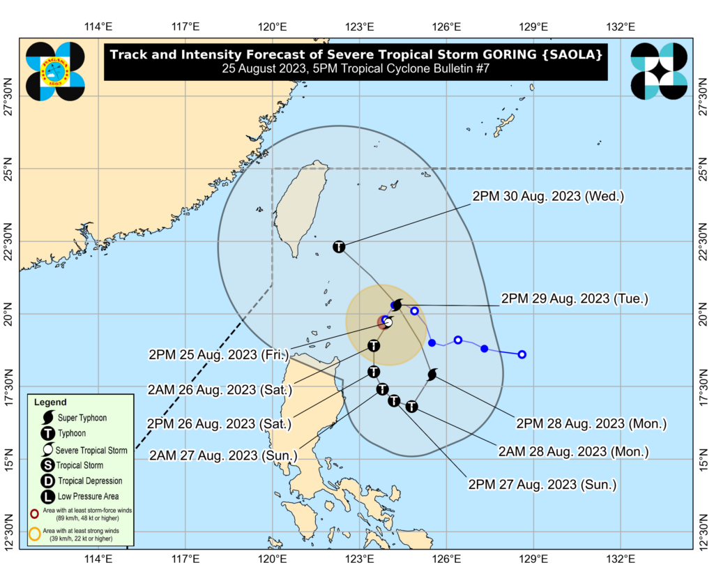
Tropical storm Goring further intensifies
Tropical Storm Goring (International name: SAOLA) continues to intensify while moving south southwestward, according to the latest bulletin of Pagasa.
In its 11 a.m. bulletin on Friday, August 25, 2023, Pagasa said the location of the center of Tropical Storm Goring was estimated to be 225 kilometers east southeast of Basco, Batanes, or 270 km east of Calayan, Cagayan.
———
Pagasa: Goring now a tropical storm; storm signals possible by Thursday night
Tropical depression Goring has intensified into a tropical storm, the Philippine Atmospheric, Geophysical and Astronomical Services Administration (Pagasa) said Thursday afternoon.
In its 5:00 p.m. update Pagasa said Goring (international name: Saola) was spotted some 265 kilometers east of Basco, Batanes.
It has maximum sustained winds of 75 kilometers per hour (kph) and gustiness of up to 90 kph. It is moving northwest at 10 kph.
———
Tropical Depression Goring may intensify into super typhoon, warns Pagasa
MANILA, Philippines — Tropical Depression Goring is expected to intensify steadily and may become a typhoon tonight or tomorrow early morning (Friday).
Its “inherent volatility” or possibility to develop into a super typhoon is not ruled out, the Philippine Atmospheric, Geophysical and Astronomical Services Administration (Pagasa) warned on Thursday.
In its bulletin issued at 11 a.m., the state weather bureau said Goring maintained its strength while moving over the Philippine Sea at least 355 kilometers east northeast of Calayan, Cagayan, or 300 kilometers east of Basco, Batanes.
Goring has maximum sustained winds of 55 kilometers per hour (kph), gustiness of up to 70 kph, and is moving north-northwestward at 15 kph.
———
The Low pressure area over the Philippine Sea, east of Aparri, Cagayan has developed into Tropical Depression Goring, Pagasa said in its 5 a.m. bulletin on Thursday, August 24, 2023.
The center of TD Goring is estimated at 400 kilometers east northeast of Aparri, Cagayan, or 405 km East of Calayan, Cagayan.
It is moving west northwestward slowly, Pagasa said.
TROPICAL CYCLONE BULLETIN NO. 1
Tropical Depression #GoringPH
Issued at 5:00 AM, 24 August 2023
Valid for broadcast until the next bulletin at 11:00 AM today.THE LOW PRESSURE AREA OVER THE PHILIPPINE SEA EAST OF APARRI, CAGAYAN HAS DEVELOPED INTO TROPICAL DEPRESSION GORING.… pic.twitter.com/Tu2HHkO0Jq
— PAGASA-DOST (@dost_pagasa) August 23, 2023
TD Goring has maximum sustained winds of 55 km/h near the center and gustiness of up to 70 km/h.
In its bulletin, Pagasa said TD Goring is less likely to bring heavy rainfall over the country in the next three days. However, considering the proximity of the tropical cyclone to land, any westward shift in the track forecast may result in heavy rainfall over portions of Cagayan Valley in the next three days.
“The Southwest Monsoon may be enhanced by this tropical cyclone beginning on Sunday or Monday, resulting in possible occasional rains over the western portions of Central and Southern Luzon,” the bulletin added.
———-
TD GORING maintains strength
Tropical Depression Goring maintained its strength as it moved north northwestward over the Philippine Sea east of Batanes late Thursday morning, August 24.
Based on a bulletin issued at 11 a.m., the location of the center of Goring was 355 kilometers east northeast of Calayan, Cagayan, or 300 km East of Basco, Batanes.
It brings with it maximum sustained winds of 55 km/h near the center, gustiness of up to 70 km/h, and central pressure of 1004 hPa, the bulletin said.
Goring is moving north northwestward at 15 km/h.
This is a developing story, please refresh for updates.
READ MORE:
Pagasa: Falcon intensifies, may develop into typhoon by Sunday
Subscribe to our regional newsletter
Disclaimer: The comments uploaded on this site do not necessarily represent or reflect the views of management and owner of Cebudailynews. We reserve the right to exclude comments that we deem to be inconsistent with our editorial standards.