LPA monitored by Pagasa-Mactan, hot weather still prevails in Cebu
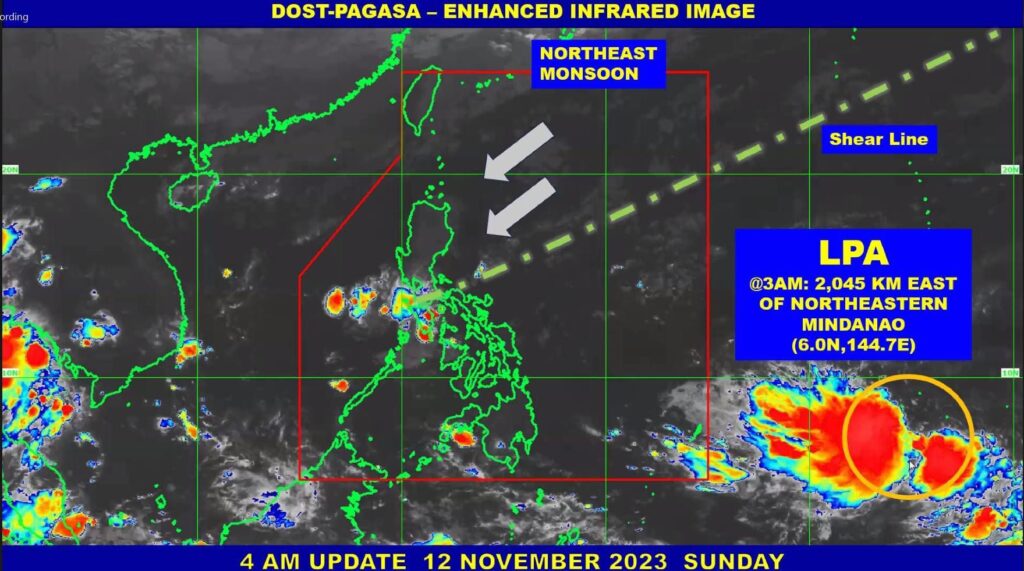
Enhanced infrared image by DOST-Pagasa
CEBU CITY, Philippines — Engineer Al Quiblat, chief of the Philippine Atmospheric, Geophysical and Astronomical Services Administration in Mactan (Pagasa-Mactan), said on Sunday, November 12, that they would continue to monitor the low-pressure area (LPA) east of Mindanao.
However, he clarified that Pagasa has not yet issued an advisory or information about the LPA, noting that its location is 2,045 kilometers east and northeast of Mindanao.
“Medyo mausab, taas kaayo ang uncertainty ani kay layo pa man,” Quiblat said.
(It may change, there is a whole lot of uncertainty on this because it is still very far.)
According to him, the LPA would possibly enter the Philippine Area of Responsibility (PAR) on Thursday, November 16.
READ: Easterlies continue to bring warm weather in PH – Pagasa
Tropical cyclone potential
“Naa tay makita sa atong tropical cyclone threat potential, moderate to high ang iyang possibility of strike sa Visayas and Southern Luzon,” he said.
Moreover, as of Sunday, Quiblat confirmed that the state weather bureau has seen a high chance that the LPA would develop into a Tropical Depression.
“Taas ang iyang chance ang iyang (LPA) gipakita karon, pero mausab pa ni. Magsige lang ta og monitor,” Quiblat said.
(On what it (LPA) has shown now, there is a high chance, but this can change. We will just continue to monitor this.)
READ: Partly cloudy to cloudy skies to prevail on Sunday, predicts PAGASA
LPA enters PAR, Pagasa then issues advisory
Once the LPA enters PAR, Quiblat said that that would be the time when Pagasa would issue an official advisory regarding its direction and where it could possibly landfall if ever it would landfall.
When asked if it could pose worry to the public, Quiblat said that they would just wait for the advisory which would be issued by Pagasa because the LPA was still far from PAR.
Meanwhile, Cebu can expect generally fair weather in the next five days, with localized thunderstorms in the afternoon and evening.
“Init ang panahon hangtud sa udto unya dunay mga chances of light to moderate passing rain pero duna sa’y chance nga occasional heavy during severe thunderstorms,” he said.
READ: Typhoon ‘likely’ to enter PAR next week – Pagasa
Warm weather, wind, temperature
(The weather will be warn until noon and there will be chances of light to moderate passing rain but there will be a chance of occasional heavy rains during severe thunderstorms.)
The wind is at 20 to 39 kilometers per hour, meanwhile the sea condition is light to moderate.
The temperature would range from 26 to 32-degrees celsius, and the expected heat index is from 39 to 40-degrees celsius.
“Wala ta’y i-expect nga i-issue nga gale warning,” Quiblat said.
(We are not expecting to issue any gale warning.)
Disclaimer: The comments uploaded on this site do not necessarily represent or reflect the views of management and owner of Cebudailynews. We reserve the right to exclude comments that we deem to be inconsistent with our editorial standards.