TD Kristine: Signal No. 1 up in 15 areas nationwide
Tropical Depression Kristine maintains its strength while lingering over the Philippine Sea, according to the state weather agency, which raised Tropical Cyclone Wind Signal No. 1 over 15 areas as of mid-day Monday, October 21, 2024. Photo from DOST-PAGASA
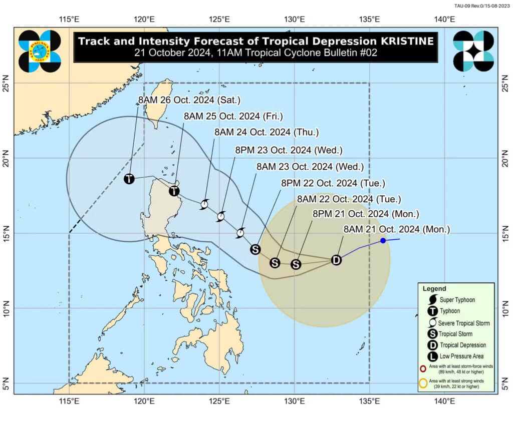
MANILA, Philippines — The state weather agency has raised Tropical Cyclone Wind Signal No. 1 over 15 areas as of mid-day Monday as Tropical Depression Kristine maintained its strength as it crosses the Philippine Sea.
Kristine was spotted 870 kilometers east of Eastern Visayas at 10 a.m. packing maximum sustained winds of 55 kilometers per hour (kph) and gustiness of up to 70 kph.
That is according to Philippine Atmospheric, Geophysical, and Astronomical Services Administration (Pagasa) in its latest typhoon bulletin
It also said that the tropical depression was moving west-southwestward at 30 kph.
READ MORE:
Kristine’s trough to bring rains in Cebu
Tropical Depression Kristine enters PAR, to intensify into a typhoon
EXPLAINER: What do color-coded rainfall warnings mean?
Based on the 11 a.m. Pagasa advisory, areas under Tropical Cyclone Wind Signal No. 1 are:
- Catanduanes
- Masbate including Ticao Island and Burias Island
- Camarines Sur
- Albay
- Sorsogon
- Camarines Norte
- Eastern portion of Quezon (Tagkawayan, Guinayangan, Buenavista, San Narciso, San Andres)
Visayas
- Eastern Samar
- Northern Samar
- Samar
- Leyte
- Biliran
- Southern Leyte
Mindanao
- Dinagat Islands
- Surigao del Norte including Siargao-Bucas Grande Group
“Minimal to minor impacts from strong winds are possible within any of the areas under Wind Signal No. 1,” Pagasa warned.
In an earlier weather report, Pagasa said Tropical Depression Kristine is forecast “to intensify into a tropical storm in the next 12 hours” as “it may reach severe tropical storm category by tomorrow (Tuesday) afternoon or evening and typhoon category by Thursday (24 October) afternoon or evening, prior to landfall over the northeastern portion of Cagayan.”
In the 11 a.m. typhoon bulletin, Pagasa said Kristine’s intensification into typhoon category will happen either Thursday or Friday, while its landfall will occur on Friday, October 25, in Northern Luzon.
Kristine is the 11th storm to hit the Philippines this year.
Disclaimer: The comments uploaded on this site do not necessarily represent or reflect the views of management and owner of Cebudailynews. We reserve the right to exclude comments that we deem to be inconsistent with our editorial standards.