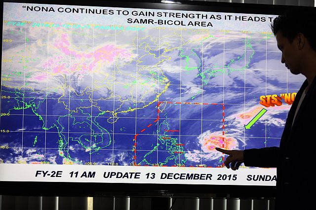
A Pagasa forecaster shows the path of typhoon Nona as it picks up strength and heads toward the Samar-Bicol area. (INQUIRER PHOTO)
Manila — Typhoon Nona (international name Melor) peaked in strength on the eve of its landfall over Samar and Bicol provinces on Monday, with winds near the center, reaching 140 kilometers per hour and gusts up to 170 kph.
The Philippine Atmospheric Geophysical Astronomical Services Administration (Pagasa) yesterday placed six provinces in the direct path of the typhoon under public storm warning signal number 3.
These are Catanduanes, Albay, Sorsogon including Ticao island, Northern Samar, Eastern Samar and Samar.
Seven provinces — Masbate including Burias Island, Camarines Sur, Camarines Norte, Romblon and Southern Quezon, Leyte and Biliran — were placed under warning signal number 2.
Signal number 1 was hoisted in Marinduque, Oriental Mindoro and rest of Quezon, Southern Leyte, Northern Cebu including Bantayan and Camotes Islands, Aklan, Capiz and Negros Occidental, Dinagat province and Siargao Island.
Pagasa said it might shortly raise warning signal number 1 over the rest of Southern Luzon, Aklan, Capiz and Metro Manila, which would be affected by the typhoon’s outer cloud band although they have not been projected to be in the path of the eye of the typhoon.
“The typhoon will be at its strongest on Monday or Tuesday,” Pagasa forecaster Robert Badrina said.
The typhoon, which moved westwards at 19 kph, carried moderate to heavy rains within its 300-km diameter, Pagasa said.
He said the typhoon would likely make landfall over Northern Samar on Monday morning and continue to cut westwards across the Samar and Bicol provinces until Wednesday.
The typhoon will start to weaken after hitting land but is expected to remain a typhoon until it exits the landmass from Mindoro province on Wednesday or Thursday if it maintains its current track, according to Pagasa.
In the next couple of days after hitting land, it will start to weaken but will remain powerful as it cuts westwards.
“It will make landfall Monday morning or noon,” Badrina of PAGASA said.
Pagasa renamed the typhoon Nona from Nonoy at the last minute early Saturday after the cyclone has reached the country’s territory.
Pagasa senior weather officer Rene Paciente was quoted as saying Science Secretary Mario Montejo ordered the change of the name since Nonoy resembled the President’s nickname, Noynoy.
Montejo reportedly did not want to associate the President’s name to a potentially damaging typhoon.
Pagasa assigns a local name to a typhoon according to a list that was prepared several years ago.
Pagasa is an agency under the Department of Science and Technology.
Disclaimer: The comments uploaded on this site do not necessarily represent or reflect the views of management and owner of Cebudailynews. We reserve the right to exclude comments that we deem to be inconsistent with our editorial standards.