Pagasa: Improved weather for Metro Cebu as Egay expected to exit PAR on Thursday

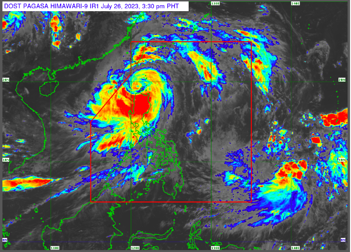
Photo screenshot from Pagasa official website
CEBU CITY, Philippines — The weather in Metro Cebu and the rest of Cebu Province is expected to get better through Sunday, July 30, 2023, as Typhoon Egay is anticipated to leave the Philippine Area of Responsibility (PAR) on Thursday morning, July 27.
Engineer Al Quiblat, Philippine Atmospheric Geophysical and Astronomical Services Administration Mactan (Pagasa Mactan) chief, said the habagat or southwest monsoon, which Typhoon Egay enhanced, caused the recent downpour and strong winds felt in Metro Cebu in the past few days.
READ: LIVE UPDATES: Typhoon Egay
Pagasa: Habagat to weaken
The habagat, however, is expected to weaken in the following days with Typhoon Egay’s exit in PAR.
“In fact, karong adlawa, medyo menus ang tsansa nga makaulan ta, kung duna man gani, mga light to moderate, hangtod na na sa Sunday,” Quiblat told CDN Digital on Wednesday, July 26.
(In fact, today, there are fewer chances of rain, if there are rains, these are light to moderate, these will be until Sunday.)
Egay expected to exit PAR
“Expected man nato ni nga mugawas ang bagyo, ugma sa buntag. Mag-anam na pod og kaayo ang atoang panahon. So, mag expect na lang ta ana og mga partly cloudy to cloudy, unya naay mga isolated nga mga pag-ulan labi na sa hapon ug gabii. Unya, kung naa pa man gani ni ang southwest monsoon o habagat nga epekto niya, hinay na,” he added.
(It is expected that the typhoon will leave the country tomorrow morning. Our weather will also slowly improve. So, we will expect partly cloudy to cloudy skies, and there will be isolated rains in the afternoon and evening. And if there is the effects of the southwest monsoon or habagat, it will only be weaker.)
READ: Egay displaces over 2,000 families in Ilocos region
Lift gale warning
Quiblat, however, asked the public to exercise caution during isolated rains brought by localized thunderstorms
He also said Pagasa could lift the gale warning they issued in some areas, including Central Visayas, within Wednesday, July 26.
As of 2 p.m. on Wednesday, the center of Typhoon Egay was estimated over the coastal waters of Calayan in Cagayan. It continues to maintain its strength while moving northwestward.
Pagasa monitors LPA
Meanwhile, the state weather bureau is currently monitoring another low pressure area of LPA, outside PAR.
Quiblat, however, said its track was recurving and it was expected to move away from the Philippines.
“So, walay chance pa karon nga mo landfall or muduol sa Pilipinas. So, kung musulod man gani ni siya adto na ni sa mga July 30, Sunday, pero didto ni siya dapita makasulod sa amihanang bahin sa PAR and then mugawas pod kuno siya on the same day ari na sa gabii,” he said.
(So, there is no chance that it will make a landfall or will move nearer to the Philippines. So, if this will really enter the country, then this will be on July 30, Sunday, but this can enter in the northern part of the PAR and then this will leave on the same day, particularly in the evening.
“Sa pagkakaron, dili pa kaayo siya significant kung naa ba siyay epekto sa Pilipinas,” he added.
(For now, there is no significant effect in the Philippines.)
READ MORE:
Pagasa: Typhoon Egay makes landfall in Aparri, Cagayan
Disclaimer: The comments uploaded on this site do not necessarily represent or reflect the views of management and owner of Cebudailynews. We reserve the right to exclude comments that we deem to be inconsistent with our editorial standards.
