Pagasa: Ruby to hit land in Northern Samar tonight
Computer generated map of typhoon Ruby’s (international name: Hagupit) landfall later today or early Sunday. (Source: www.westernpacificweather.com)
As Ruby nears land, Pagasa is expected to raise storm signal warnings to 3 and 4 for areas near the eye of the storm.
Weather in Eastern Visayas started to deteriorate last night as the outer rain band of typhoon Ruby (international name: Hagupit) started to sweep inland.
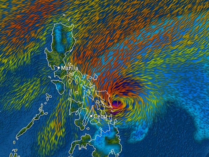
The Philippine Atmospheric, Geophysical and Astronomical Services Agency (Pagasa), said as of 8 p.m., the eye of Ruby was seen 340 kilometers east of Borongan, Eastern Samar and moving west at a slow pace of 10 kilometers per hour.
Pagasa noted slight weakening of “Ruby’s” strength at 195 kilometers per hour (kph) and gusts of 230 kph.
Even if it decreased in maximum wind speed, Ruby is still very strong.
As Ruby nears land, Pagasa is expected to raise storm signal warnings to 3 and 4 for areas near the eye of the storm.
The Joint Typhoon Warning Center of the US Navy in Hawaii classified it as a supertyphoon, while the Japan Meteorological Agency described it as a violent storm.
Ruby’s strength is comparable to typhoon Pablo (Bopha) which hit southeastern and northeastern Mindanao on Dec. 4. 2012. Pablo caused about 1,900 deaths.
Pagasa forecasts Ruby to hit land Saturday evening in Eastern Samar.
Meteorologists worry that its slow ground speed could mean more rainfall and higher risk of flooding and landslides.
“The big threat will be heavy rainfall from this storm. It will be moving at a very slow pace across the Philippines thus bringing heavy showers over an extended period of time.
“The heaviest rainfall will likely be in Samar where over 500mm could result in a serious risk of flooding and landslides,” said Robert Speta, a meteorologists at the westernpacificweather.com.
Pagasa is predicting heavy to intense rain (7.5 – 20 mm/hour), especially in areas within the path of Ruby in the Visayas.
Rainfall is also expected within a 600-kilometer diameter — up to Metro Manila in the north and down to northern Mindanao.
Speta’s rainfall prediction is comparable to actual rainfall dumped by tropical depression Sendong (Washi) that caused massive flooding in Cagayan de Oro and Iligan cities in northern Mindanao leaving over a thousand dead on Dec. 16 and 17, 2011. “Sendong” was a weak tropical storm, packing maximum winds of up to 100 kph, but cruising at a very slow speed of 12-14 kph.
48-hour forecast
In its 5 p.m. Public Storm Signal Warning no. 2 has been raised in northern Cebu, Cebu City, including the islands of Bantayan and Camotes. Also in signal no. 2 were Northern Samar, Eastern Samar, Samar, Biliran, Leyte, Southern Leyte, Albay, Sorsogon, Ticao Island and Masbate.
It is forecast to be 80 kilometers north northeast of Borongan, Eastern Samar by around 5 p.m. today. If it maintains its ground speed, the eye of the storm could hit land late Saturday evening or early Sunday morning in Eastern Samar.
By Sunday afternoon, “Ruby” is forecast to be 40 km north of Masbate City or in the vicinity of Ticao Island. By Monday afternoon, it is projected to be 50 km west of Calapan City, Oriental Mindoro.
Disclaimer: The comments uploaded on this site do not necessarily represent or reflect the views of management and owner of Cebudailynews. We reserve the right to exclude comments that we deem to be inconsistent with our editorial standards.