Gale warnings may be raised in Visayas during weekend due to effects of Mawar
CEBU CITY, Philippines — Pagasa may issue a gale warning on Saturday afternoon, May 27, 2023, or Sunday morning, May 28, all over the Visayas, according to an official of the weather bureau stationed in Mactan, Cebu.
Engineer Al Quiblat, chief of the Philippine Atmospheric Geophysical and Astronomical Services Administration-Mactan (Pagasa-Mactan), told CDN Digital on Friday afternoon, May 26, that they were not discounting the possibility of raising a gale warning in the entire Visayas over the weekend due to the enhanced habagat (southwesterly wind), which would be the indirect effect of Super Typhoon Mawar in the region.
READ: Super typhoon Mawar slightly intensifies, to enter PH as Betty
Mawar’s effects in Visayas
Once a gale warning is issued, the Philippine Coast Guard could issue advisories suspending trips and voyages of small sea vessels.
“Ang epekto sa ato diri, dili sa circulation sa bagyo (Super Typhoon Mawar), kon dili, ang pagkusog sa habagat (enhanced Southwesterly wind). Gihigop man niya,” Quiblat said, noting that the maximum wind speed in Central Visayas might reach 60 kilometers per hour next week.
(The effect here is not in the circulation of the typhoon (Super Typhoon Mawar), but in the enhanced southwesterly wind. It is being absorbed.)
“Atong expected ani (the indirect effect of Mawar) is hangtod sa Thursday next week. Dili angay mo kompyansa kay gawas sa light to moderate (rains), posible man na naay mga thunderstorms,” he said.
(What we will be expecting (the indirect effect of Mawar) is until Thursday next week. We should not let our guard down because aside from the light to moderate (rains), it is possible that there will be thunderstorms.)
READ: Super Typhoon Mawar further intensifies; may reach peak force in 24-36 hrs – Pagasa
Extended weather outlook
Based on the state-weather bureau’s extended weather outlook, the coastal water condition in Metro Cebu and the rest of Cebu Province on Saturday would be moderate to rough on Sunday, and rough to very rough coastal water condition on Monday, with an expected wave height of 2.4 to 4.1 meters.
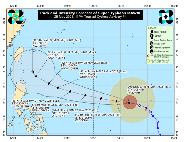
The Super Typhoon was last spotted at 1,705 kilometers East of Southeastern Luzon, with maximum sustained winds of 215 kilometers per hour (kph) near the center and gusts of up to 260 kph.
It is moving west northwestward with a speed of 20 kph and is expected to enter the Philippine Area of Responsibility on Friday evening, May 26, or Saturday morning, May 27.
READ: 2 sea trips in Cebu City, Calbayog City temporarily suspended for maintenance, Mawar
Extreme northern Luzon
“And then muduol didto sa Monday sa extreme northern Luzon. Ang distanya niya didto dapita sa Batanes is mga 250 kilometers and dayon, sa Martes, mo recurve, mopalayo sa nasud, moving towards southern Japan,” Quiblat said.
(And then on Monday, it will go near extreme northern Luzon. It distance from Batanes then will be around 250 kilometers and on Tuesday, it will recurve, moving away from the country, moving towards southern Japan.)
Quiblat, however, said the super typhoon Mawar had a slim chance of making a land fall, based on its forecast track.
RELATED STORIES
Most of Guam without power, water after Super Typhoon Mawar exits
#WalayKlase: Class suspensions in Cebu as of May 26, 2023 due to Super Typhoon Mawar
Disclaimer: The comments uploaded on this site do not necessarily represent or reflect the views of management and owner of Cebudailynews. We reserve the right to exclude comments that we deem to be inconsistent with our editorial standards.