LPA will not affect Visayas – Pagasa Mactan
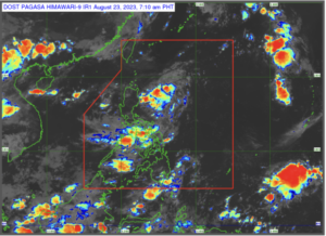
The LPA sighted east Cagayan may develop into a tropical cyclone. (Photo by Pagasa)
CEBU CITY, Philippines — The low-pressure area (LPA) spotted in Cagayan is not going to affect Visayas, according to an official of the state weather bureau stationed in Mactan on Wednesday, August 23, 2023.
Engineer Al Quiblat, chief of the Philippine Atmospheric, Geophysical and Astronomical Services Administration Mactan (Pagasa Mactan), said that they would continue to monitor a low-pressure area (LPA) inside the country’s area of responsibility.
LPA won’t affect Visayas
According to him, the LPA is located 245 kilometers east of Aparri, Cagayan in Northern Luzon.
Quiblat told CDN Digital on Wednesday, August 23, that there would be a chance that the LPA would become a tropical depression.
However, he noted that there would be nothing to worry about in the Visayas.
“Layo mani siya. East [of] Aparri, Cagayan, so most likely dili ni maka apekto sa Visayas area, particularly sa Central Visayas. Mag expect lang gihapon ta og southwest monsoon (habagat) maoy mo epekto nato for the next five days,” he said.
(It is far. East of Aparri, Cagayan, so most likely this will not affect the Visayas area, particularly in Central Visayas. But we still will expect the southwest monsoon, (habagat), that will still affect us for the next five days.)
Weather condition from Thursday to Sunday
Quiblat said that starting tomorrow, August 24 until Sunday, August 27, Visayas can experience the effects of southwest monsoon.
Moreover, starting August 24, he said that the sky condition would be expected to be partly cloudy to cloudy and chances of rain due to localized thunderstorms carried by the southwest monsoon.
“Katong low-pressure area, may chance nga mahimong bagyo [pero] layo ra sa Visayas. Wala’y epekto sa Visayas. Ang ato lang bantayan [ang] kining southwest monsoon or habagat,” he added.
(This low pressure area, it will have a chance to become a storm [but] it is far from the Visayas. It has no effect on the Visayas. What we will, however, will be be southwest monsoon or habagat.)
He said that the chances of rain could be experienced “within the day or anytime of the day” but it would more likely occur in the afternoon and in the evening.
Wind condition
Meanwhile, the wind condition is light to moderate starting tomorrow until Saturday, August 26.
For the coastal waters, the condition is also light to moderate.
“Di ta maka expect nga maka issue ta og gale warning,” he noted.
(You cannot expect us to issue a gale warning then.)
However, on Sunday, Quiblat said that the southwest monsoon would slightly intensify.
“Mahimong 350 kilometers per hour ang gikusgon sa hangin, unya moderate to rough ang atoang sea condition, pero di gihapon ta maka expect nga maka issue ta og gale warning,” he said.
(The wind speed will become 350 kilometers per hour, and the sea condition will become moderate to rough, but you cannot still expect us to issue a gale warning.)
Furthermore, the range of temperature tomorrow is from 24 to 31 degrees celsius, on Friday is 25 to degrees celsius, for Saturday and Sunday it will be 26 to 32 degrees celsius.
READ MORE:
Habagat to continue to bring rains in Metro Cebu — Pagasa
Extreme heat will be experienced in Metro Cebu this weekend – Pagasa Mactan
Huge parts of Visayas, Mindanao to see rains due to ‘habagat’ — Pagasa
/dbs
Disclaimer: The comments uploaded on this site do not necessarily represent or reflect the views of management and owner of Cebudailynews. We reserve the right to exclude comments that we deem to be inconsistent with our editorial standards.