Kabayan develops into a tropical storm, Cebu still at Signal No. 1
MANILA, Philippines — Cebu remains at Storm Signal No. 1 and other areas in Mindanao are under Storm Signal No. 2 after Tropical Depression Kabayan (International name: Jelawat) developed into a tropical storm.
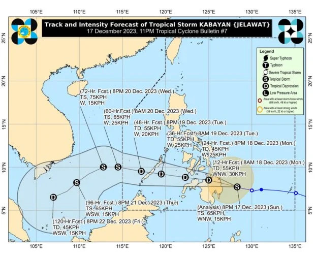
That is according to Philippine Atmospheric, Geophysical and Astronomical Services Administration (Pagasa), which added that Kabayan is moving west-northwestward of the Philippine Sea.
READ: Tropical Storm Kabayan: LIVE UPDATES
11 PM bulletin on Kabayan, areas under Signal No. 2
Kabayan was last seen 275 kilometers east of Davao City while accelerating at the speed of 15 km per hour (kph), Pagasa said.
Based on its 11 p.m. cyclone bulletin, Kabayan carries maximum sustained winds of 65 kph with gusts of up to 80 kph.
This development has prompted the state weather service to raise Tropical Cyclone Wind Signal (TCWS) Number 2 in Dinagat Islands, Surigao del Norte, including Siargao and Bucas Grande Islands, Surigao del Sur, the northern portion of Agusan del Norte, the eastern portion of Agusan del Sur, and the northern portion of Davao Oriental.
READ: Cebu under Signal No. 1 as Kabayan nears Mindanao
Areas under Signal No. 1
Meanwhile, the following areas remain under Storm Signal No. 1:
Visayas
- Southern Leyte
- Leyte
- the southern portion of Samar — Basey, Santa Rita, Marabut, Talalora, Villareal, Pinabacdao)
- the south portion of Eastern Samar (Maydolong, City of Borongan, Quinapondan, Guiuan, Lawaan, Balangiga, Llorente, Giporlos, Salcedo, Balangkayan, General Macarthur, Hernani, Mercedes)
- Cebu, including Camotes Islands
- Bantayan Islands
- Bohol
- Siquijor
READ: TD Kabayan: PCG bans vessels from sailing in E. Samar, S. Leyte
Mindanao
- rest of Agusan del Norte
- rest of Agusan del Sur
- central portion of Davao Oriental (Banganga, Manay, Caraga
- Davao de Oro
- Davao del Norte
- Davao City
- Camiguin
- Misamis Oriental
- Misamis Occidental
- Lanao del Norte
- Lanao del Sur
- northern portion of Maguindanao del Norte — Buldon, Barira, Matanog
- northern portion of Cotabato — Arakan, Camen, Banisilan, Alamada, President Roxas, Kabacan, Matalam, Antipas, Magpet
- northern portion of Zamboanga del Sur — Midsalip, Labangan, Tukuran, Aurora, Sominot, Ramon Magsaysay, Tambulig, Dumingag, Mahayag, Josefina, Molave
- northeastern portion of Zamboanga del Norte — Siayan, Sindangan, Jose Dalman, Manukan, President Manuel A. Roxas, Sergio Osmeña Sr., Katipunan, Dipolog City, Polanco, Mutia, Piñan, Dapitan City, Sibutad, La Libertad, Rizal
READ: Pagasa: TD Kabayan may hit Surigao del Sur or Davao Oriental
Kabayan landfall
Kabayan is expected to make its first landfall along the coast of Surigao del Sur or Davao Oriental tonight or tomorrow morning, the agency’s bulletin said.
“Due to frictional effects associated with landfall, Kabayan is forecast to weaken over land, and the possibility of being downgraded into a low-pressure area, while over land or after emerging over the sea is not ruled out,” Pagasa added.
The tropical depression is also expected to make another landfall over central or southern Palawan Tuesday morning.
Disclaimer: The comments uploaded on this site do not necessarily represent or reflect the views of management and owner of Cebudailynews. We reserve the right to exclude comments that we deem to be inconsistent with our editorial standards.