Nika may become typhoon late Sunday; Signal # 2 up in 9 areas

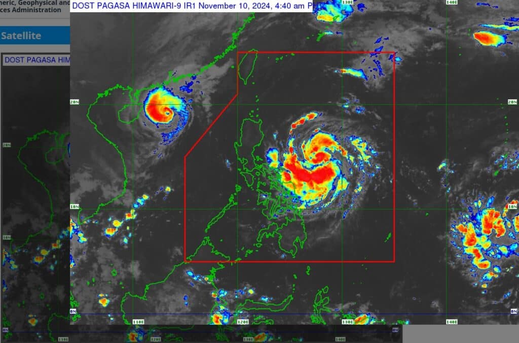
Satellite image from Pagasa
MANILA, Philippines — Tropical Storm Nika (international name: Toraji) further intensified as it moves westward over the Philippine sea, according to the Philippine Atmospheric, Geophysical and Astronomical Services Administration (Pagasa) on Sunday.
In a 2 p.m. bulletin, Nika was last spotted some 425 kilometers (km) east of Infanta, Quezon, packing maximum sustained winds of 110 kilometers per hour (kph) and gusts of up to 135 kph.
Strong to storm-force winds may also extend outwards up to 340 km from the center, the state weather bureau said.
ALSO READ:
Nika sustains strength, signal no. 2 up in parts of Luzon
‘Nika’ intensifies into severe tropical storm; new LPA spotted
Nika may become a severe storm by Monday; hit Isabela or Aurora
Pagasa further advised that Nika is expected to strengthen into a typhoon by Sunday and may reach its peak intensity before making landfall over Isabela or Aurora on Monday morning or early afternoon.
Due to these developments, Pagasa raised Tropical Cyclone Wind Signal (TCWS) No. 2 in the following areas:
- Northern and central portions of Aurora (Dilasag, Casiguran, Dinalungan, Dipaculao, Maria Aurora, Baler)
- Isabela
- Quirino
- Southern portion of Cagayan (Solana, Iguig, Peñablanca, Tuguegarao City, Enrile)
- Nueva Vizcaya
- Kalinga
- Mountain Province, Ifugao, the eastern portion of Benguet (Mankayan, Buguias, Kabayan, Itogon, Bokod, Atok)
- Northern portion of Nueva Ecija (Carranglan, Pantabangan)
- Northeastern portion of Pangasinan (San Nicolas, Natividad, San Quintin)
Gale-force winds, ranging from 62 to 88 kph, are expected to impact areas under TCWS No. 2, posing minor to moderate threat to life and property.
Tropical Cyclone Signal No. 1
Meanwhile, the following areas were placed under TCWS No. 1, where strong winds from 39 to 61 kph may be expected:
- The rest of Cagayan including Babuyan Islands
Apayao - Abra
- Ilocos Norte
- Ilocos Sur
- The rest of Pangasinan
- La Union
- The rest of Benguet
- The rest of Aurora, Tarlac
- Northern and central portions of Zambales (Santa Cruz, Candelaria, Masinloc, Palauig, Iba, Botolan, Cabangan, San Marcelino, San Felipe, San Narciso)
- The rest of Nueva Ecija
- Pampanga
- Bulacan
- Metro Manila
- Rizal
- Eastern portion of Laguna (Santa Maria, Mabitac, Pakil, Pangil, Famy, Siniloan, Paete, Kalayaan, Cavinti, Lumban, Luisiana, Santa Cruz, Magdalena, Pagsanjan, Majayjay, Liliw, Nagcarlan, Pila, Victoria)
- Eastern portion of Quezon (Calauag, Guinayangan, Tagkawayan, Pitogo, San Andres, Buenavista, San Francisco, Pagbilao, Infanta, Lopez, Catanauan, Mulanay, Unisan, General Luna, Plaridel, Quezon, Alabat, Sampaloc, Padre Burgos, Macalelon, Mauban, Perez, Agdangan, Gumaca, Atimonan, Real, San Narciso, General Nakar, Lucban, City of Tayabas, Lucena City) including Pollilo Islands
- Camarines Norte
- Camarines Sur
- Catanduanes
- Albay (Malinao, Tiwi, Bacacay, City of Tabaco, Malilipot, Rapu-Rapu)
Pagasa also hoisted a gale warning over the eastern seaboard of Southern Luzon.
Disclaimer: The comments uploaded on this site do not necessarily represent or reflect the views of management and owner of Cebudailynews. We reserve the right to exclude comments that we deem to be inconsistent with our editorial standards.
