Low-pressure area outside PAR may still re intensify this weekend
The low-pressure area that is currently east of northeastern Mindanao has a slim chance of intensifying into a storm today, Wednesday, November 15, 2023, according to Pagasa in its latest weather forecast.
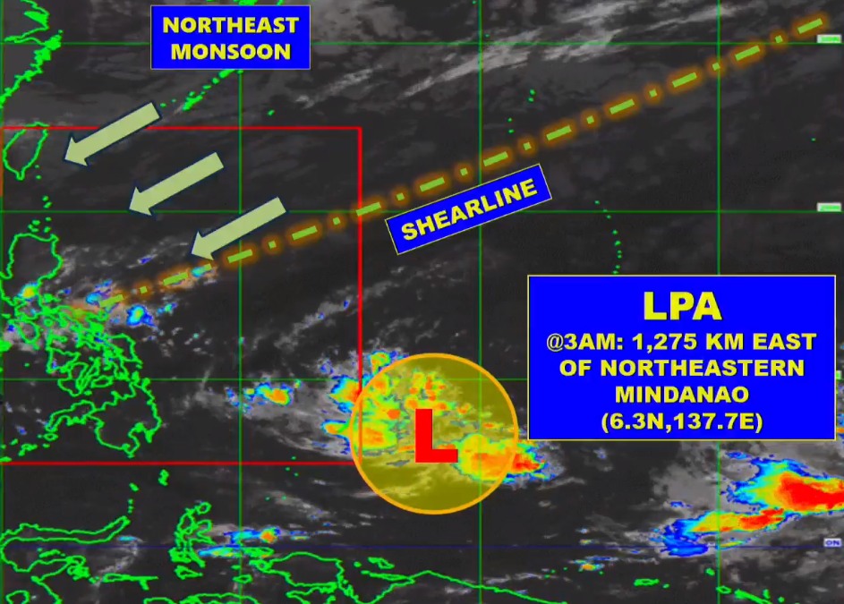
Weather specialist Obet Badrina, in a live forecast around 4 a.m. Wednesday, said Pagasa is monitoring the low-pressure area (LPA) that is still outside the Philippine Area of Responsibility (PAR).
The LPA, as of 3 a.m. Wednesday, was 1,275 kilometers east of northeastern Mindanao.
READ MORE: Tropical Depression weakens into low-pressure area
Badrina said it still has no direct affect on the country.
“Sa ngayon, base sa pinakahuling datos, medyo maliit yung chance na maging bagyo within the day, pero hindi natin inaalis yung possibilidad na sa mga sumusunod na araw, lalo na bandang Biyernes o hanggang weekend, ay posible itong maging bagyo pa rin, mag re intensify at inaasahan pa rin natin na papasok ng Philippine Area of Responsibility sa mga susunod na mga araw, bagamat sa nagyon, wala itong direktang epekto sa anumang bahagi sa ating bansa,” he said.
(For now, based on the latest data, there’s a slim chance that it will become a storm within the day, but we are not discounting the possibility that in the coming days, especially on Friday or on the weekend, it will become a storm and re-intensify and we expect it to enter the PAR in the coming days although for now, it still has no direct effect on the weather in the country.)
READ MORE: Pagasa-Mactan warns of fake ‘strong typhoon’ updates
Shear line affecting eastern parts of the country
Badrina, though, said that what is affecting the country is the shear line that will bring some rain to the southern Luzon.
The Northeast monsoon, or amihan, is also affecting northern and central Luzon.
But he said the rest of the country will have generally fair weather with chances of rain in the afternoon and evening.
Samar and Eastern Samar will have cloudy skies with scattered rainshowers and thunderstorms due to shear line.
Central Visayas, Western Visayas, Leyte, Southern Leyte, Palawan, including Kalayaan Islands and Occidental Mindoro, will have partly cloudy to cloudy skies with isolated rainshowers and/or thunderstorms due to shear line/ localized thunderstorms.
Light to Moderate winds from the northeast will prevail over the whole Visayas, Palawan including Kalayaan Islands, and Occidental Mindoro with slight to moderate seas.
ALSO READ
Cebu City prepares for possible weather disturbance this week
Quezon towns suspend classes due to bad weather
Disclaimer: The comments uploaded on this site do not necessarily represent or reflect the views of management and owner of Cebudailynews. We reserve the right to exclude comments that we deem to be inconsistent with our editorial standards.