Tropical Storm Helen enters PAR, TD Gener exits – Pagasa
Helen would not directly affect any part of the country - state weather bureau
Pagasa.gov.ph
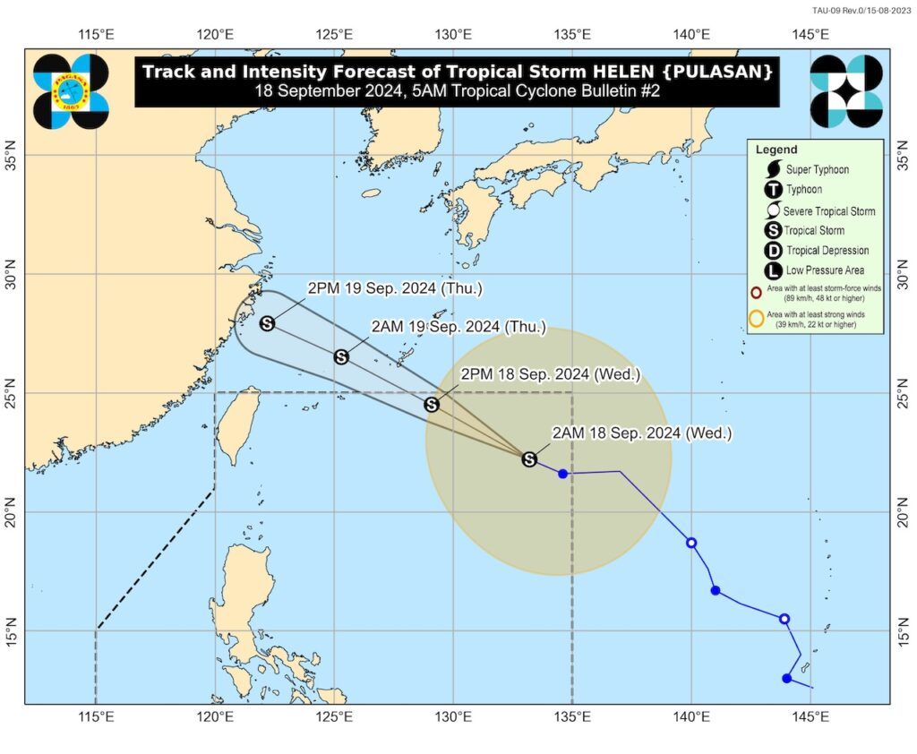
CEBU, Philippines —Tropical Storm Helen (International name: Pulasan) has entered the Philippine Area of Responsibility (PAR) in the early evening of Tuesday, the state weather bureau said.
According to the Philippine Atmospheric Geophysical Astronomical Services Administration (Pagasa), Helen is forecast to move generally west northwestward for the next 48 hours and may exit the PAR region tomorrow afternoon (September 19).
READ MORE:
LIST: Philippine Typhoon Names for 2024
Tropical Depression Gener: Signal No. 1 up in 24 areas
Gener update: TD maintains strength while moving over N. Luzon
LIVE UPDATES: Tropical Depression Gener
The state weather bureau in its 5 a.m. weather advisory also said that Helen throughout the forecast period would remain far from the Philippine land mass and would not directly affect any part of the country.
As for Tropical Depression Gener, it has exited the country and is moving westward to Vietnam.
Pagasa said in its September 17, 11 p.m. advisory, Gener was spotted at 10 p.m. on Tuesday 365 kilometers west of Bacnotan and was expected to exit PAR at midnight of Tuesday.
“Inaasahan po na kikilos ito pawestward patungo po sa may central portion of Vietnam,” said Benison Estareja, Pagasa weather specialist, on Gener in its September 17, 11 p.m. advisory.
(It is expected to move westward heading to central portion of Vietnam.)
In Pagasa’s 5 a.m., September 18 advisory, Gener is out of PAR and is spotted at 410 km West of Bacnotan, La Union (outside PAR).
Still both weather systems will continue to enhance the southwest monsoon, which will bring moderate to heavy rains in most parts of Luzon.
According to Pagasa’s September 18, 5 a.m. weather advisory, moderate to heavy rains due to the southwest monsoon will affect the following areas in Luzon: Metro Manila, Ilocos Region, Cordillera Administrative Region, Zambales, Bataan, Batangas, Cavite and the rest of Mimaropa.
Heavy rains would be experienced in Palawan and Occidental Mindoro due to the habagat, said Pagasa in the advisory.
Pagasa also said that strong to gale force winds would also be experienced in these areas due to the Gener and Helen enhanced habagat.
These are Zambales, Bataan, Pampanga, Bulacan, Metro Manila, CALABARZON, MIMAROPA, Bicol Region, Visayas, and Mindanao.
Pagasa is advising small seacrafts including motorbancas not to venture out to sea under these conditions.
Disclaimer: The comments uploaded on this site do not necessarily represent or reflect the views of management and owner of Cebudailynews. We reserve the right to exclude comments that we deem to be inconsistent with our editorial standards.