Supertyphoon Hinnamnor to enter PAR Thursday, may become ‘almost stationary’ in northern Luzon
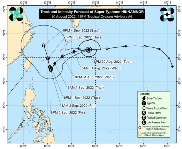
Track of Supertyphoon Hinnamnor. Image from Pagasa
MANILA, Philippines — Supertyphoon Hinnamnor is likely to enter the Philippine area of responsibility (PAR) by evening Wednesday or early Thursday morning based on the track and intensity forecast of the state weather bureau.
In its 5AM weather bulletin, the Philippine Atmospheric Geophysical and Astronomical Services Administration (Pagasa) said based on the latest track of Hinnamnor — which will be named “Henry” once it reaches PAR — was last located 1,305 kilometers east-northeast of extreme northern Luzon, packing maximum sustained winds of 195 kph with gustiness up to 240 kph.
“Magiging west-southwestward, magiging pababa ang pagkilos nito (Hinnamnor), papasok yan sa loob ng ating PAR kung saan inaasahan natin na mamayang gabi o bukas ng early morning yung posibilidad na ito’y nasa loob na ng ating PAR,” forecaster Grace Castañeda said.
Pagasa said Hinnomnor is likely to decelerate once it reaches the northern Philippine Sea so that by late Thursday through Friday it may become “almost stationary.”
“Magiging mabagal ang pagkilos nitong Bagyong Hinnomnor at posibleng maging almost stationary ito by late Thursday or though Friday,” Castañeda added.
“Hinnamnor may reach a peak intensity of 205 kph within 24 hours before gradually weakening as it enters its quasi-stationary phase. This tropical cyclone may be downgraded to typhoon category by Friday,” Pagasa said in its advisory.
This means that the weather disturbance will have a bigger diameter in Pagasa’s monitoring instruments, and will have an effect of increased possibility of raising a tropical cyclone wind signal over the area of extreme northern Luzon, such as Batanes and Babuyan Islands.
Light to moderate rains to sometimes heavy rains with isolated thunderstorms may also be expected by late Thursday or Friday as Hinnamnor enhances the southwest monsoon or “habagat” in a large swathe of western Luzon, including Metro Manila.
While Pagasa said that Hinnamnor may not make a landfall in any part of the country, it will still dump huge volumes of rainfall in extreme northern Luzon and Luzon, causing floods and landslides.
Meanwhile, Pagasa is also monitoring Tropical Depression Gardo, which was last seen moving north-northwestward as it interacts with Hinnamnor. The two weather systems so far has no direct effect but may likely induce habagat rains.
Gardo is currently 1,130 kilometers east of extreme northern Luzon, packing maximum sustained winds of 85 kilometer per hour (kph) with gustiness of up to 70 kph.
Pagasa said Gardo is forecast to move generally northward or north northwestward as it interacts with Hinnamnor outside of PAR.
“’Gardo’ will degenerate into a remnant low [pressure area] this afternoon or evening as ‘Hinnamnor’ begins to assimilate its circulation,” said Pagasa
RELATED STORIES
LPA east of Luzon intensifies into a tropical depression
Tropical depression Florita maintains strength; Signal No. 1 in 12 Luzon areas
‘Florita’ intensifies into tropical storm; Signal No. 2 raised in 4 areas
Disclaimer: The comments uploaded on this site do not necessarily represent or reflect the views of management and owner of Cebudailynews. We reserve the right to exclude comments that we deem to be inconsistent with our editorial standards.