Pagasa: Heavy to torrential rains felt in cities of Cebu, Mandaue on Friday
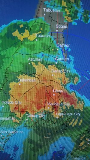
Pagasa-Mactan radar image as of 1:40 p.m. on Friday, Sept. 9, 2022. | Photo courtesy of Jhomer Eclarino
CEBU CITY, Philippines — The Philippine Atmospheric Geophysical and Astronomical Services Administration (Pagasa) based in Mactan, Cebu said “heavy to torrential” rains due to severe localized thunderstorms were felt in Metro Cebu on Friday, Sept. 9, 2022.
Jhomer Eclarino, Pagasa-Mactan weather forecaster, said that torrential rains (or a rainfall intensity of more than 30 millimeters per hour) were particularly felt in Cebu City and Mandaue City on Friday afternoon, as heavy downpour was concentrated in these two neighboring cities.
Eclarino said their Mactan radar logged rainfall estimation of 30 millimeters (mm) to 60 mm in these two localities from 1 p.m. to 2 p.m. on Friday.
“Mas naunang naulan diri sa northern part ng Metro Cebu, kasama yung Cebu City, Mandaue City, Liloan, and Consolacion… Naa tay estimation diri sa atong Mactan radar, ang nauwan diha possibly sa Cebu City and Mandaue City is mga torrential rain or more than 30 mm,” he said.
“Ang kining more than 30 mm amount of rainfall, equivalent kini sa more than 150,000 barrels of rain per square kilometer,” he added, noting that each mm of rainfall is equivalent to 5,000 barrels or drums of rain per square kilometer.
Pagasa Mactan started issuing thunderstorm advisories before noon of Friday until the afternoon.
Pagasa divides rainfall intensity into seven categories: light (less than 2.55 mm per hour); light to moderate (2.5 to 4.5 mm per hour); moderate (4.5 to 5.5 mm/hour); moderate to heavy (5.5 to 7.5 mm per hour); heavy (7.5 to 15 mm per hour); intense (15 to 30 mm per hour), and torrential (more than 30 mm of rains per hour).
Torrential rains, Eclarino said, could cause landslides and heavy flooding in prone areas.
Eclarino said that the waterspout that was spotted in Lapu-Lapu waters on Friday, Sept. 9, was also an indication of the intense or severe thunderstorms that affected the city on Friday.
He, however, clarified that the severe localized thunderstorms felt in Metro Cebu on Friday was not an effect of the severe tropical storm Inday currently being monitored.
READ: Inday now a severe tropical storm, may become a typhoon – Pagasa
“So, localized thunderstorms mahitabo siya maski walay weather system basta init kaayo in the morning going afternoon. So, makadevelop kini ng mga convective clouds or kining mga localized thunderstorms,” he said.
He said that the STS Inday had no direct effect to Central Visayas as its extension or trough had been forecast to affect only Panay Island and Samar Province in the Visayan islands.
Metro Cebu could then expect a generally fair weather, with chances of localized thunderstorms (with a duration of one to two hours), this weekend, he said.
RELATED STORIES
STS Inday’s trough brings cloudy skies, rain as it approaches Batanes
LOOK: Over 400 families in Mandaue, Consolacion evacuated due to rise in water level
Friday afternoon downpour causes flooding, traffic buildup at Fernan bridge
Inday still not expected to make landfall, says Pagasa
Butuanon River overflows, records highest water level yet
/dbs
Disclaimer: The comments uploaded on this site do not necessarily represent or reflect the views of management and owner of Cebudailynews. We reserve the right to exclude comments that we deem to be inconsistent with our editorial standards.