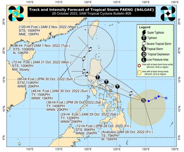
Paeng advances: 6 areas under Signal No. 2, 17 others under Signal No. 1

DOST_pagasa
MANILA, Philippines — State meteorologists placed six areas in the country under Signal no. 2 and 17 others under Signal no. 1 as Tropical Storm Paeng (international name: Nalgae) nears the Philippine landmass on Friday.
The Philippine Atmospheric, Geophysical and Astronomical Services Administration (Pagasa) said Paeng was last located 410 kilometers east of Borongan City, Eastern Samar, packing maximum sustained winds of 75 kilometers per hour (kph) and gustiness of 90 kph.
Based on Pagasa’s 5 a.m. weather bulletin, a Tropical Cyclone Wind Signal (TCWS) is hoisted over the following areas:
Signal No. 2
- Catanduanes
- Albay
- Sorsogon
- Eastern portion of Camarines Sur (Caramoan, Garchitorena, Presentacion, Lagonoy, Goa, San Jose, Tigaon, Iriga City, Saglay, Buhi)
- Northern Samar
- Northern portion of Eastern Samar (Jipapad, Arteche, Oras, San Policarpo, Maslog, Dolores, Can-Avid, Taft)
Signal No. 1
- Masbate including Ticao and Burias Islands
- Camarines Norte
- Rest of Camarines Sur
- Romblon
- Marinduque
- Quezon including Polillo Islands
- Laguna
- Rizal
- Samar
- Rest of Eastern Samar
- Biliran
- Leyte
- Southern Leyte
- Northern portion of Cebu (Daanbantayan, Medellin, San Remigio, Tabogon, City of Bogo, Borbon) including Bantayan and Camotes Islands
- Dinagat Islands
- Surigao del Norte including Siargao and Bucas Grande Islands
- Northern portion of Surigao del Sur (Carrascal, Cantilan, Madrid, Carmen, Lanuza, Cortes, City of Tandag, Bayabas, Tago, Cagwait)
“Winds may reach gale-force strength during the passage of Paeng within any of the areas where Tropical Cyclone Wind Signal No. 2 is hoisted. Strong winds may be experienced within any of the areas where Tropical Cyclone Wind Signal No. 1 is hoisted throughout the entire passage of Paneg,” Pagasa explained.
Rain is also expected to prevail over a large portion of the country due to Paeng’s size, according to Pagasa weather specialist Benison Estreja.
“Nakakaapekto na itong malalakas na ulan dulot ni Paeng sa Visayas, and Mindanao, maging dito rin po sa Bicol Region and Mimaropa. Sa mga sususnod na oras, makakaranas na rin ng pag-ulan ang ilang bahagi ng Calabarzon, itong Metro Manila, and Aurora, hanggang dito sa Cagayan and Isabela, dahil po sa paglapit ni Bagyong Paeng at dun na rin sa trough na tinatawag,” Estreja said during Pagasa’s weather report early Friday.
(Heavy rains caused by Paeng are affecting Visayas and Mindanao, as well as the Bicol Region and Mimaropa. In the coming hours, rain will prevail in some parts of Calabarzon, Metro Manila and Aurora, all the way to Cagayan and Isabela, as Tropical Storm Paeng approaches and also due to its so-called trough.)
The state weather bureau then warned that areas affected by rain may see landslides and floods.
It further said that a gale warning was raised over the coasts of Ilocos Norte, Ilocos Sur, La Union, Pangasinan, Batanes, Cagayan and the Babuyan Islands, Aurora, Isabela, north and east portion of Quezon and the Polillo Islands, Camarines Norte, north Camarines Sur, Catanduanes, east coast of Albay, east coast of Sorsogon, Northern Samar, and Eastern Samar.
Pagasa’s latest tracking of Paeng has indicated that the tropical storm may hit Catanduanes or pass very close to the province by morning of Saturday, October 29.
RELATED STORIES
#PaengPH displaces 70 individuals in Mandaue
#PaengPH: Cebu LGUs told to regularly monitor surroundings
LIST: Cancelled flights to and from Cebu due to #PaengPH
LPA now Tropical Depression ‘Paeng’
Disclaimer: The comments uploaded on this site do not necessarily represent or reflect the views of management and owner of Cebudailynews. We reserve the right to exclude comments that we deem to be inconsistent with our editorial standards.
