
(This is a developing story, please refresh for updates)
Pagasa: Dodong strengthens into tropical storm before PAR exit
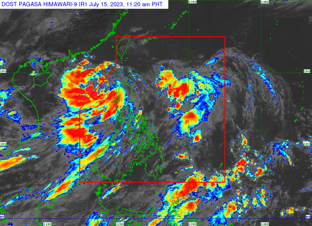
Weather satellite image from Pagasa’s website
The Philippine Atmospheric, Geophysical and Astronomical Services Administration (Pagasa) on Saturday said Tropical Depression Dodong has intensified into a tropical storm.
Pagasa’s 11 a.m. weather bulletin indicated that Dodong was on his way out of the Philippine area of responsibility, moving north-northwestward at 10 kilometers per hour. It was last located 305 kilometers west of Sinait, Ilocos Sur.
Pagasa also said that Dodong has maximum sustained winds of 65 kph and gustiness of up to 80 kph.
Pagasa lifts all wind signals as Tropical Depression Dodong crosses West PH Sea
All Tropical Cyclone Wind Signals (TCWS) have been lifted as Tropical Depression Dodong cut across the West Philippine Sea, the state weather bureau said Saturday.
In its 5 a.m. bulletin, the Philippine Atmospheric, Geophysical and Astronomical Services Administration (Pagasa) said Dodong was last seen 270 kilometers west of Sinait, Ilocos Sur, packing maximum sustained winds of 55 kilometers per hour (kph) near the center and gustiness of up to 70 kph.
Dodong was moving westward at 20 kph, it added.
Dodong leaving faster but rains to persist in Luzon — Pagasa
Tropical Depression Dodong’s speed has increased slightly as of Friday afternoon.
However, the state weather bureau reported rains will still prevail in various areas due to the southwest monsoon or habagat.
This means the cyclone is moving out of the Philippine area of responsibility faster and earlier.
It will exit between Saturday night and Sunday morning.
But downpours will still be experienced, especially over western parts of Luzon due to habagat.
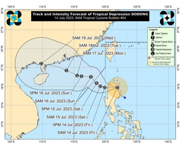
Tropical Depression Dodong’s track. Photo from Pagasa’s website
Tropical Depression Dodong makes landfall in PH: 16 areas under Signal No. 1 – Pagasa
The low pressure area in northern Luzon strengthened early Friday morning, July 14, 2023, and is now known as Tropical Depression Dodong, the state weather bureau said.
Consequently, the Philippine Atmospheric, Geophysical and Astronomical Services Administration (Pagasa) raised Tropical Cyclone Wind Signal (TCWS) No. 1 over 16 areas where strong winds between 39 and 61 kilometers per hour (kph) may be expected – which pose “minimal to minor threat to life and property.”
According to Pagasa’s latest weather bulletin, Dodong already made landfall in Dinapigue, Isabela, as of 5:00 a.m. Friday and presently in the vicinity of San Mariano, Isabela, packing maximum sustained winds of 45 kph and gustiness of 75 kph.
Tropical Cyclone Wind Signal numbers raised
As of 8:00 a.m. of Friday, July 14, Tropical Cyclone Wind Signal numbers have been raised over the following areas in Luzon due to Tropical Depression. #CDNDigital #DodongPH
Pagasa says Tropical Depression Dodong to leave PAR over the weekend
Tropical Depression Dodong is forecast to exit the Philippine area of responsibility (PAR) this weekend, the Philippine Atmospheric, Geophysical and Astronomical Services Administration (Pagasa) said.
Based on its 8 a.m. weather bulletin Friday, Dodong is projected to move westward or west-northwestward of Luzon’s northern portion and cross waters located west of the Ilocos Region.
#WalangPasok: Class suspensions for July 14 due to Tropical Depression Dodong
Several classes in both private and public schools were suspended Friday, July 14, due to Tropical Depression Dodong.
The state weather bureau said Dodong – the fourth tropical cyclone to hit the Philippines in 2023 – is forecast to cross northern Luzon on Friday. It may initially go northwestward over Cagayan Valley before veering west-northwestward to Ilocos Region.
As of 7:50 a.m., July 14, classes were suspended in the following provinces due to bad weather:
- San Fernando, Pampanga (all levels)
- Cagayan (pre-school to senior high school)
Update on Tropical Cyclone Wind signals
As of 11:00 a.m. of Friday, July 14, Tropical Cyclone Wind Signal numbers have been raised over the following areas due to Tropical Depression.
/bmjo
Subscribe to our regional newsletter
Disclaimer: The comments uploaded on this site do not necessarily represent or reflect the views of management and owner of Cebudailynews. We reserve the right to exclude comments that we deem to be inconsistent with our editorial standards.