(Update as of 9:12 a.m. on July 30, 2023)
Here’s the latest update on Tropical Storm Falcon which entered the Philippine Area of Responsibility (PAR) early on Saturday morning, July 29, 2023.
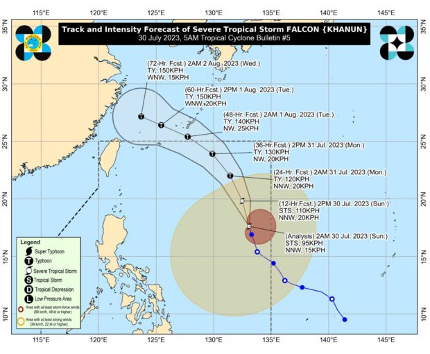
Pagasa monitors Falcon was last seen 1,190 kilometers (km) east of Northern Luzon moving 15 kilometers per hour (kph) and carrying maximum sustained winds of 95 kph and gusts of up to 115 kph. (Photo courtesy of Pagasa)
Pagasa: Falcon intensifies into severe tropical storm
Tropical Storm Falcon (international name: Khanun) has developed into a severe tropical storm as it moves north-northwestward over the Philippine Sea, the state weather bureau said on Sunday.
In its 5 a.m. weather bulletin, the Philippine Atmospheric, Geophysical and Astronomical Services Administration’s (Pagasa) said Falcon was last seen 1,190 kilometers (km) east of Northern Luzon moving 15 kilometers per hour (kph) and carrying maximum sustained winds of 95 kph and gusts of up to 115 kph.
According to Pagasa, Falcon has enhanced the southwest monsoon or “habagat,” which will bring occasional monsoon rains over the western portions of Luzon and Visayas in the next three days.
The state weather bureau added that it would unlikely hoist a wind signal in any parts of the country, but Falcon may bring gusty conditions in Zambales, Bataan, Pampanga, Bulacan, Metro Manila, Occidental Mindoro, Palawan, Romblon, Northern Samar, and most of Calabarzon (Cavite, Laguna, Batangas, Rizal and Quezon), Bicol Region and Western Visayas on Sunday.
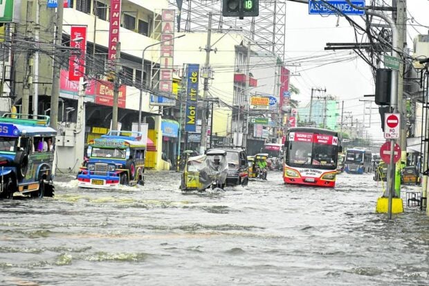
DAGUPAN NAVIGATION | A combination of high tide and heavy rains brought about by Typhoon “Egay” resulted in this situation in one of Dagupan City’s commercial areas on Saturday. A total of 31 barangays in the city were flooded and at least 245 families were forced to evacuate, officials said. (Photo by WILLIE LOMIBAO / Inquirer Northern Luzon)
Falcon looms as PH still reels from Egay
A tropical storm east of the Philippines was drawing seasonal rain clouds into the country on Saturday and threatened more flooding and landslides over the next three days as provinces devastated by Typhoon Egay (international name: Doksuri) were still trying to recover.
A “generally higher” rainfall is expected over mountainous areas of the country as Tropical Storm Falcon (international name: Khanun), continues to enhance the southwest monsoon, the Philippine Atmospheric, Geophysical and Astronomical Services Administration (Pagasa) said.
“Under these conditions, flooding and rain-induced landslides are highly likely, especially in areas that are highly or very highly susceptible to these hazards as identified in hazard maps and in localities that experienced considerable amounts of rainfall for the past several days,” the state weather bureau said.
This will likely be the case in some localities that experienced heavy rainfall in the past days due to the southwest monsoon, or “habagat,” that had been enhanced by Falcon.
The tropical storm was forecast to become a typhoon on Sunday. It was centered around 1,205 kilometers east of Central Luzon over the Philippine Sea on Saturday afternoon and moving northward with maximum sustained winds of 75 km per hour and gusts of up to 90 kph.
Pagasa said it was unlikely that it would raise storm wind alerts because Falcon was far from the nearest landmass, Luzon.
Falcon may become typhoon late Sunday, but landfall expected in China
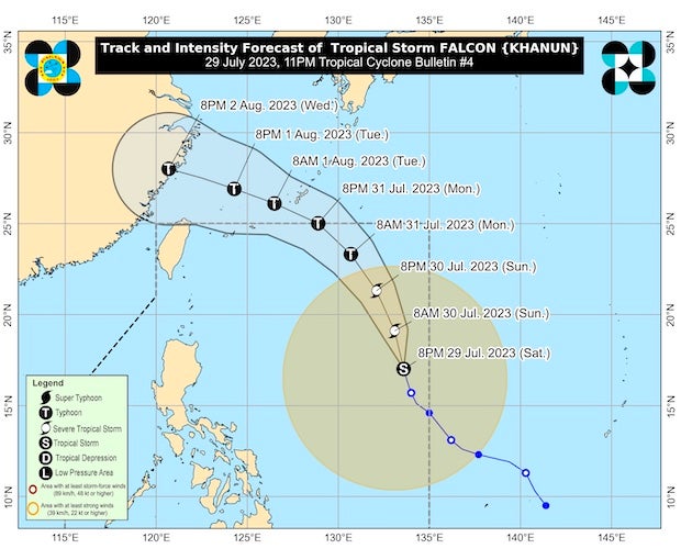
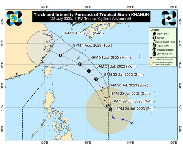
Tropical Storm Falcon (international name: Khanun) has further intensified over the Philippine Sea and is expected to do so steadily within the next three days.
It’s forecast to become a typhoon between late Sunday evening and Monday morning and reach its peak intensity on Tuesday.
It’s not expected to make landfall in the Philippines but in China on Wednesday afternoon or evening, according to the Saturday 11 p.m. bulletin of the Philippine Atmospheric, Geophysical and Astronomical Services Administration (Pagasa).
The storm is currently located about 1,210 kilometers east of Central Luzon and is moving north-northwestward at 15 kph. It has maximum sustained winds of 85 kph with a gustiness of up to 105 kph,
Pagasa warned of heavy rainfall and strong winds over the western portions of Luzon and Visayas in the next three days.
Pagasa: Falcon intensifies, may develop into typhoon by Sunday
Tropical Storm Falcon (international name: Khanun) has intensified while accelerating northwest over the Philippine Sea and may develop into a typhoon by Sunday, the state weather bureau said Saturday.
In its Saturday afternoon bulletin, the Philippine Atmospheric, Geophysical and Astronomical Services Administration (Pagasa) said the eye of Falcon was last plotted some 1,205 kilometers east of Central Luzon, and increased its maximum sustained winds from 65 kilometers per hour (kph) to 75 kph, gustiness from 80 kph to 90 kph while moving north at 20 kph from 10 kph hours earlier.
“Falcon is forecast to steadily intensify within the next three days. It is forecast to become a typhoon Sunday (July 30) afternoon or evening and reach its peak intensity on late Monday (July 31) or early Tuesday (August 1),” Pagasa said.
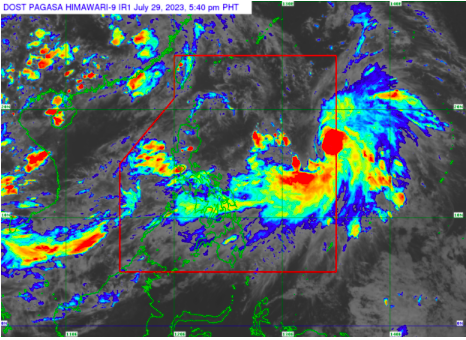
The track of Tropical Storm Falcon. | Pagsa_DOST
Khanun enters PAR, now called tropical storm Falcon — Pagasa
The tropical storm with the international name Khanun has entered the Philippine area of responsibility (PAR) and was given the local name Falcon, said the state weather bureau.
Philippine Atmospheric, Geophysical and Astronomical Services Administration (Pagasa) weather specialist Benison Estareja said Falcon entered the country’s area of responsibility at 11 p.m. on July 28.
Falcon was last seen 1,360 kilometers east of Central Luzon. It has maximum sustained winds of 65 kilometers per hour and gustiness of up to 80 kph.
It is moving west-northwestward at 15 kilometers per hour.
Pagasa: Tropical Storm Khanun to enter PAR as Falcon early Saturday
Tropical Storm Khanun will enter the Philippine area of responsibility (PAR) on Saturday morning, state meteorologists said.
Khanun was last located 1,245 kilometers east northeast of southeastern Luzon, packing maximum sustained winds of 65 kilometers per hour (kph) with gustiness of 80 kph, according to the Philippine Atmospheric, Geophysical and Astronomical Services Administration’s (Pagasa) Friday bulletin.
“Khanun is forecast to enter the Philippine area of responsibility in the next 12 hours,” the Pagasa said in its 11 p.m. advisory.
Once inside PAR, the tropical storm will be called Falcon.
The tropical storm, however, is forecast to remain far from the Philippine landmass before going out of PAR by Monday.
Disclaimer: The comments uploaded on this site do not necessarily represent or reflect the views of management and owner of Cebudailynews. We reserve the right to exclude comments that we deem to be inconsistent with our editorial standards.