

photo: earth.nullschool.net
(UPDATED, JULY 18, 8:04 a.m.) Here are the latest updates on Tropical Depression (TD) ‘Crising,’ which developed into a TD on Wednesday, July 16, 2025.
READ: LIST: Philippine typhoon names for 2025
Bookmark this page then refresh and scroll down to get updates on Crising, which is the third tropical cyclone of 2025 or the second for the month of July.
LPA develops into tropical depression ‘Crising’
The low-pressure area (LPA) within the Philippine Area of Responsibility (PAR) has developed into a tropical depression and is named ‘Crising.’
In Pagasa’s advisory issued at 10 a.m. on Wednesday, July 16, TD Crising is said to be located 780 kilometers east of Virac Catanduanes, packing winds of 45 kilometers per hour (KPH) and gustiness of 50 KPH. It is moving westward at 35 KPH.
TD Crising may become tropical storm by Thursday – Pagasa
The Low Pressure Area being monitored inside the Philippine Area of Responsibility (PAR) has already developed into Tropical Depression “Crising,” Pagasa said. Crising is forecasted to reach Tropical Storm category by Thursday morning, July 17, and will continue to intensify over the Philippine Sea and may reach Severe Tropical Storm category by Friday afternoon or evening as it approaches Northern Luzon.
“Further intensification up to Typhoon category prior to approach is not ruled out,” Pagasa said.
TD Crising enhances habagat: Cebu braces for heavy rains, rough seas
Cebu is bracing for cloudy skies, scattered heavy rain, and rough seas from July 16 to 19, as the southwest monsoon (habagat), intensified by Tropical Depression Crising, sweeps across the Visayas.
Engineer Al Quiblat, chief of the Philippine Atmospheric, Geophysical and Astronomical Services Administration (PAGASA) – Mactan, said in a text message on Wednesday that while the region will not experience a direct hit from TD Crising, the tropical depression is enhancing the southwest monsoon, bringing moderate to at times heavy rainfall and moderate to strong winds.
“[Ang] indirect effect sa TD Crising nga masinati sa Visayas ang kining pagkusog unya sa habagat,” Quiblat said.
He added, however, that moderate to rough sea conditions are expected by Friday and Saturday.
Pagasa: Tropical Depression Crising threatens northern Luzon
On Thursday morning, Tropical Depression Crising is expected to develop into a storm. It may also reach severe tropical storm category by Friday afternoon or evening before it approaches northern Luzon.
Crising was last located 625 kilometers east of Virac, Catanduanes, said the Philippine Atmospheric, Geophysical and Astronomical Services Administration (Pagasa) in its 5 p.m. advisory on Wednesday.
It has maintained its strength with a maximum wind speed of 45 kilometers per hour (km/h) and gustiness of up to 55 km/h while moving west-northwestward at 20 km/h.
Pagasa added that Crising “may pass close or make landfall over mainland Cagayan or Babuyan Islands from Friday evening to early Saturday morning.” It will then move northwestward and may exit the Philippine area of responsibility (PAR) by Saturday afternoon or evening.
Crising intensifies, signal No. 1 up in parts of Luzon
Tropical Depression Crising is forecasted to reach Tropical Storm category today, July 17, and Severe Tropical Storm category while it approaches northern Luzon on Friday, according to the Pagasa.
As of 4 a.m. on Thursday, the center of TD Crising was located 535 km East of Juban, Sorsogon. It has maximum sustained winds of 55 km/h near the center, gustiness of up to 70 km/h, and central pressure of 1000 hPa.
Tropical Cyclone Wind Signal No. 1 is currently up in Cagayan including Babuyan Islands, Isabela, the northeastern portion of Aurora (Dilasag, Casiguran, Dinalungan, Dipaculao), Quirino, Kalinga, the eastern portion of Mountain Province (Sadanga, Barlig, Paracelis, Natonin), the eastern portion of Ifugao (Alfonso Lista, Aguinaldo, Mayoyao, Banaue, Hingyon, Lagawe, Lamut), the northeastern portion of Nueva Vizcaya (Kasibu, Quezon, Bagabag, Diadi) and Apayao in Luzon.
WAY KLASE: Some Cebu LGUs suspend classes due to ‘bad weather’
Some localities or local government units in Cebu have announced the suspension of classes today, July 17, as a result of unfavorable weather conditions and to ensure the safety of learners and teachers.
Click the link above to check the list.
Weather outlook for the weekend
Update on suspension of classes in Cebu
Crising 11 a.m. update
Rains in Cebu to last until the weekend – Pagasa
The public here is advised to take precautions against possible heavy rains as inclement weather will likely last until this Saturday, July 19.
The habagat or southwest monsoon continues to affect many parts of the country, including Cebu, according to the latest forecast from the state weather bureau.
While Tropical Depression Crising does not directly impact Visayas, it pulls the habagat, effectively bringing rains in Cebu and to more areas in the Philippines.

Crising maintains strength, more areas under Signal No. 1
More areas have been placed under Tropical Cyclone Wind Signal No. 1 as Tropical Depression (TD) Crising maintained its strength, the weather bureau said in its 11 a.m. bulletin on Thursday.
The cyclone packs maximum sustained winds of 55 kilometers per hour (kph) near the center, gustiness of up to 70 kph. It was located 520 kilometers east northeast of Juban, Sorsogon, or 470 km. east northeast of Virac, Catanduanes as of 10 a.m., moving north northwestward at 25 kph.
CEBU CITY WAY KLASE SA BIYERNES
WAY KLASE SA BIYERNES ANG MANDAUE CITY
WAY KLASE SAD SA LAPU-LAPU SA BIYERNES

Crising turns into a tropical storm, 8 Luzon areas under Signal No. 2
Tropical Depression Crising is now a tropical storm (international name: Wipha). This as it intensified into a storm on Friday morning prompting eight areas in northern Luzon to be placed under Tropical Cyclone Wind Signal (TCWS) No. 2.
The eye of the the center of Crising was spotted some 335 kilometers (Kms.) east of Echague, Isabela or 325 kms. east of Tuguegarao City, Cagayan, said the Philippine Atmospheric, Geophysical and Astronomical Services Administration (Pagasa) in its 5:00 a.m. update on Friday, July 18.
The tropical storm packs a maximum sustained wind speed of 65 kph near the center and gustiness of up to 80 kph while moving northwest at 20 kph.
Crising will continue to intensify until it reaches Severe Tropical Storm category by tomorrow morning or afternoon, Pagasa said.
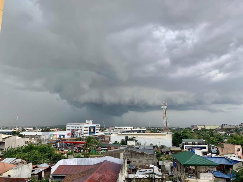
Dark rain clouds hover over some areas of Metro Cebu | FILE PHOTO/Brian Ochoa
Crising’s pull brings more rains to Cebu, fair weather by Sunday
Storm or no storm, Cebu is still in for a wet ride.
Although not directly hit by Tropical Storm Crising, the weather system’s pull on the southwest monsoon (habagat) continues to dump rains across the Visayas, with local weather officials warning of cloudy skies, moderate to heavy rains, and rough seas until Saturday, July 19.
Engineer Alfredo Quiblat Jr., chief of the Philippine Atmospheric, Geophysical and Astronomical Services Administration (Pagasa) Mactan Station, said the weather in Cebu is still being affected by Crising’s indirect impact as of Friday, July 18.

Philippine Coast Guard 5 (Bicol) Commander, Commodore Ivan Roldan (Photo courtesy of PCG-5)
Crising: Nearly 100 passengers, 34 RoRos stranded in ports in Bicol
Nearly 100 passengers are stranded in three ports in the Bicol region due to Tropical Storm Crising, the Philippine Coast Guard (PCG) said on Friday.
In a phone interview, PCG 5 (Bicol) Commander, Commodore Ivan Roldan, said 64 passengers and 21 roll-on/roll-off (RoRo) ships are stranded at the Tabaco Port in Albay province, 27 passengers and 13 RoRos in Virac Port and seven passengers in San Andres Port, both in Catanduanes province.
Four vessels are also stranded in Tabaco Port and three in Virac Port, where one boat is also seeking shelter.
Subscribe to our regional newsletter
Disclaimer: The comments uploaded on this site do not necessarily represent or reflect the views of management and owner of Cebudailynews. We reserve the right to exclude comments that we deem to be inconsistent with our editorial standards.