


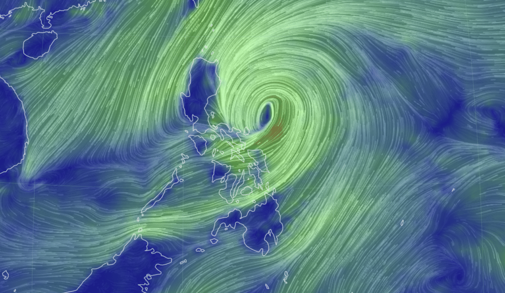
earth.nullschool image
(UPDATED: 7: 35 p.m., October 25) Check out the latest weather update on Tropical Storm Kristine.
Bookmark this page for the latest updates on #KristinePH.
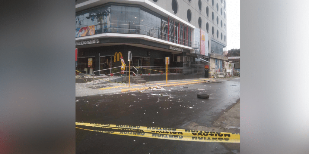
Kristine: Floods submerge towns, death toll rises to 66

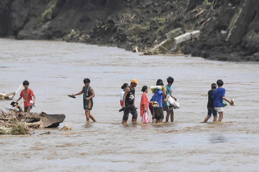
People cross a river next to a bridge that collapsed after the river overflew due to heavy rains brought about by Tropical Storm Trami in Laurel, Batangas province, south of Manila on October 25, 2024. | Photo by Ted ALJIBE / AFP
Residents of the northern Philippines used spades and rakes to clear their homes of mud and debris on Friday while others still awaited rescue as the death toll from Severe Tropical Storm Kristine (international name: Trami) rose to 66.
Tens of thousands remained displaced after fleeing floods driven by a torrential downpour that dumped two months’ worth of rainfall over just two days in some areas.
READ full story here.
Kristine leaves towns submerged, 40 dead

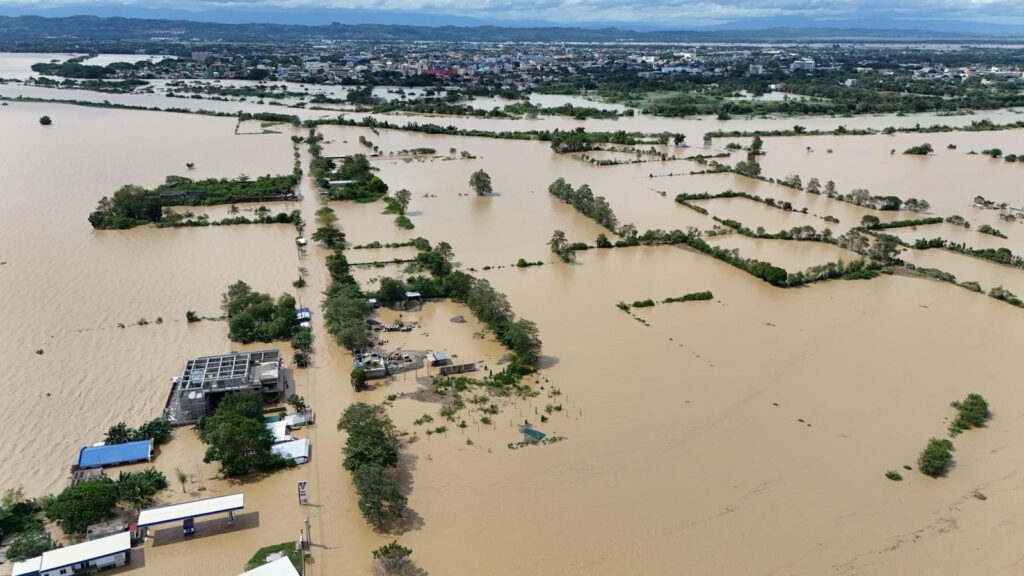
This aerial photo shows houses submerged in flood due to the heavy rains brought about by Tropical Storm Trami in Tuguegarao City, province of Cagayan on October 25, 2024.| Photo by John Dimain / AFP
MANILA, Philippines — Rescue workers battled floodwaters Friday to reach residents still trapped on the roofs of their homes as Severe Tropical Storm Kristine (international name: Trami) moved out to sea after killing at least 40 people.
Tens of thousands remained displaced after fleeing floods driven by a torrential downpour that dumped two months’ worth of rainfall in just two days in some areas.
READ full story here.
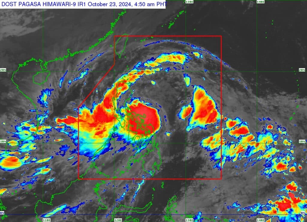
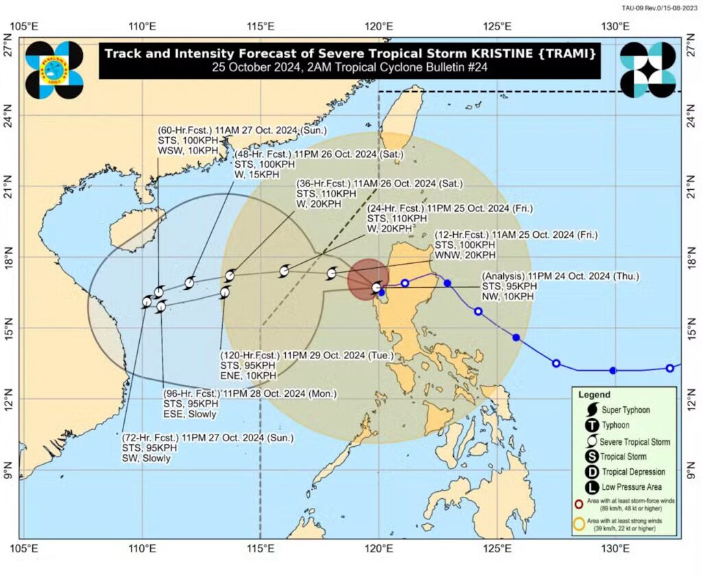
Kristine outlook: Will it loop back towards PAR?
As severe tropical storm Kristine moves further away from the Philippine landmass on Friday, October 25, 2024, Pagasa said in its latest bulletin that re-entry to the Philippine Area of Responsibility (PAR) is not being ruled out.
In Pagasa’s 5 a.m. bulletin on Friday, its track and intensity outlook said that Kristine is forecast to move west northwestward to westward over the next 48 hours and exit the PAR region in the afternoon.
In the extended outlook, Pagasa also said there is a developing forecast situation wherein Kristine will be looping over the West Philippine Sea on Sunday, October 27, and Monday, October 28, and move generally eastward towards the general direction of the PAR region. Re-entry to the PAR is not being ruled out.
Read full story here.
Kristine moving farther away from Philippine landmass – Pagasa

MANILA, Philippines —Severe Tropical Storm Kristine (international name: Trami) has turned northwest early Friday morning moving farther away from Philippine landmass.
That is according to Philippine Atmospheric, Geophysical and Astronomical Services Administration (Pagasa).
As of 2:00 a.m., Kristine, which was packing maximum sustaned winds of 95 kilometers per hour (kph) near its center with gustiness of 115 kph, was spotted 115 kilometers west of Bacnotan, La Union. And it was moving northwest at 10 kph.
READ full story here.
Kristine also felt in Mandaue, Cebu: Strong wind fell trees

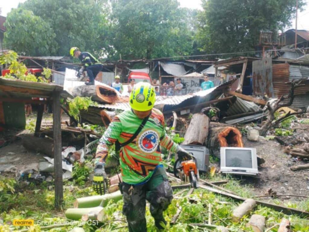
Paknaan Responders responded to the large tree that fell in Zone Sayote Barangay Paknaan on Thursday morning, Oct. 24 due to the strong winds brought by typhoon Kristine.| Bantay-Mandaue CDRRMO
MANDAUE CITY, Philippines — Some trees in different barangays in Mandaue City have fallen due to strong winds brought by Severe Tropical Storm Kristine.
On Thursday, morning, Oct. 24, an old tree fell in Zone Sayote, Barangay Paknaan. The tree fell on a parked motorcycle and damaged the nearby house.
While on Wednesday, some trees were also uprooted in Barangays Umapad and Paknaan. Other than the trees, a tarpaulin of a billboard in Barangay Subangdaku was almost torn away by the strong winds and the flapping tarpaulin nearly hit the electric wires.
READ full story here.
Cargo vessel runs aground in Minglanilla

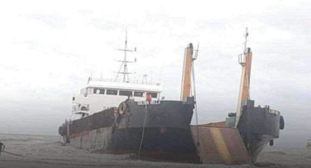
LCT Golden Bella was moored in the seawaters in Minglanilla when two of its anchors got loose. Strong winds led it to drift close to the shores of Brgy. Calajoan in Minglanilla. | PCG-7
CEBU CITY, Philippines — A cargo vessel ran aground off the coast of Minglanilla town, southern Cebu due to strong wind and rough seas brought by Severe Tropical Storm Kristine (international name: Trami).
Fortunately, no one was harmed as Coast Guard personnel started hull inspection of the ship, the Philippine Coast Guard in Central Visayas (PCG-7) said.
READ full story here.
Fujiwhara effect? Kristine to return? Pagasa addresses claims
The chief of the state weather bureau in Mactan said on Thursday that they had seen no scenarios yet that Severe Tropical Storm (STS) Kristine would return to the country.
Engineer Alfredo Quiblat, chief of Philippine Atmospheric, Geophysical and Astronomical Services Administration (Pagasa-Mactan), said in a phone interview that there is a scenario when STS Kristine would attempt to return to the country after it exits the Philippine Area of Responsibility (Par).
But he clarified that there had been no scenarios that would actually tell that STS Kristine would enter PAR, only it would recurve.
Read full story here.
Kristine leaves 1 dead in Cebu
Severe Tropical Storm Kristine (international name: Trami) left one fatality in Cebu where it brought strong wind and occasional rains.
The victim was identified as 70-year-old Rodulfo Villar, the fisherman who went missing since Tuesday, October 22, after the boat he and two other companions used to sail from Leyte to Pilar in Camotes Island capsized due to rough seas.
The Cebu Provincial Disaster Risk Reduction and Management Office (PDRRMO) confirmed that Villar’s body had been found on the shores of Merida town in Leyte on Wednesday, October 23.
Read full story here.
Kristine also felt in Mandaue, Cebu: Strong wind fell trees
Some trees in different barangays in Mandaue City have fallen due to strong winds brought by Severe Tropical Storm Kristine.
On Thursday, morning, Oct. 24, an old tree fell in Zone Sayote, Barangay Paknaan. The tree fell on a parked motorcycle and damaged the nearby house.
While on Wednesday, some trees were also uprooted in Barangays Umapad and Paknaan. Other than the trees, a tarpaulin of a billboard in Barangay Subangdaku was almost torn away by the strong winds and the flapping tarpaulin nearly hit the electric wires.
| Pagasa photo
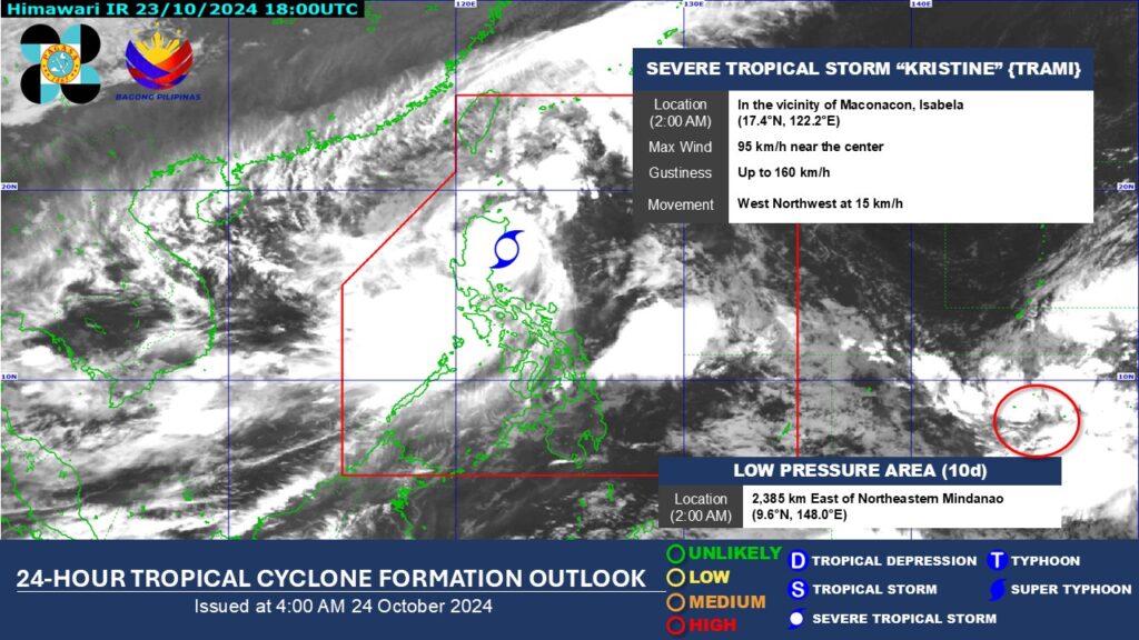
Weather update: Another LPA forms outside PAR
Another low pressure area (LPA) has developed outside the Philippine Area of Responsibility (PAR), Pagasa said in its latest report.
According to Weather Specialist Benison Estareja, the LPA is around 2,400 kilometers east of northeastern Mindanao as of 2 a.m. Thursday morning, October 24.
Read full story here.
Pagasa: Kristine makes landfall in Isabela
Severe tropical storm Kristine (International name: Trami), at 12:30 a.m., Thursday, October 24, made landfall in Divilacan town in Isabela province.
This was according to the state weather bureau in its 2 a.m. weather bulletin.
The Philippine Atmospheric, Geophysical and Astronomical Services Administration (Pagasa) said that Kristine had maximum sustained wind speeds of 95 kilometers per hour near the center and was moving northwestward 15 km/h.
Read full story here.
Kristine: Severe tropical storm to make landfall over Isabela
Severe Tropical Storm #KristinePH (International name: TRAMI), is about to make landfall over Isabela, according to the 11 p.m. bulletin of Pagasa on Wednesday, October 23, 2024.
The location of the center of Kristine, as of 10 p.m., was estimated to be over the coastal waters of Palanan, Isabela.
Kristine is bringing maximum sustained winds of 95 km/h near the center, gustiness of up to 130 km/h, and central pressure of 985 hPa
Read full story here.
Kristine batters Luzon: 14 dead, thousands evacuated
Rescuers waded through chest-deep floodwaters on Wednesday, October 23, to reach residents trapped by Severe Tropical Storm Kristine (International name: Trami), which has killed 14 people and forced thousands to evacuate as it barrels toward the east coast of the Philippines.
Torrential rain has turned streets into rivers, submerged entire villages and buried some vehicles in volcanic sediment set loose by the downpour.
Read full story here.
LPA develops outside PAR
As severe tropical storm #KristinePH nears Isabela, Pagasa says a Low Pressure Area (10d) has developed outside the Philippine Area of Responsibility at 8 p.m. on Wednesday.

LIST: Class suspensions in Cebu for Oct. 24 due to #KristinePH
Classes are still suspended this Thursday, October 24, in at least 19 areas in Cebu due to threats of Severe Tropical Storm Kristine.
As of 8:30 p.m., on Wednesday, October 23, the following local governments announced that classes remained cancelled for Thursday.
Read full story here.
PCG-7 on heightened alert due to Tropical Storm Kristine
Personnel of the Philippine Coast Guard in Central Visayas (PCG-7) are now on heightened alert amid the onslaught of Tropical Storm Kristine.
Ensign Abel Lomboy, the PCG-7 Information Officer, said that they had been on heightened alert since Wednesday morning after the Philippine Atmospheric Geophysical and Astronomical Services Administration (Pagasa) placed majority of the region under Tropical Cyclone Wind Signal (TCWS) No. 1 due to the storm.
As of this writing, the center of the tropical storm Kristine was estimated to be at 155 kilometers east of Casiguran, Aurora.
Read full story here.
Kristine’s effects felt in Cebu: 4 missing, classes cancelled, buildings damaged

Even if it was out of the storm’s path, Cebu was not spared by the effects of Tropical Storm Kristine.
The storm, which brought heavy rains and caused severe flooding in the Bicol region, has prompted local governments here to suspend classes, implement preemptive evacuation and cancel sea trips.
The bad weather also resulted in four people missing after their boats capsized while trying to sail from Leyte to Cebu, the Provincial Disaster Risk Reduction and Management Office (PDRRMO) confirmed.
Read full story here.
Close to 500 passengers stranded in Central Visayas
CEBU CITY, Philippines — Following the cancellation of sea trips, close to 500 individuals were left stranded in various ports in Central Visayas, the Philippine Coast Guard (PCG) here said.
In its latest report, the PCG in the region (PCG-7) recorded a total of 490 passengers from 66 vessels stranded as of 8 a.m. on Wednesday, October 23.
They also noted 35 vessels, including motorbancas, taking shelter in ports.
Sea voyages to and from Central Visayas have been cancelled since Monday, October 22 due to threats of Tropical Storm Kristine.
The state weather bureau has also placed majority of the region under Tropical Cyclone Wind Signal (TCWS) No. 1.
READ full story here.
Cebu class suspension update due to Kristine
Some Cebu areas under Signal No. 1
The state weather bureau has hoisted Storm Signals in several areas in Cebu as Tropical Storm Kristine moves closer to northern Luzon on Wednesday, October 23, 2024.
The Philippine Atmospheric Geophysical and Astronomical Services Administration (Pagasa) placed a total of 38 localities in the northern and central portions in Cebu under Tropical Cyclone Wind Signal (TCWS) No. 1.
Kristine update: More areas under signal no. 2
Tropical Storm Kristine (International name: TRAMI), has slightly intensified over the sea east of Quezon in the latest update of Pagasa on Wednesday, October 23, 2024.
As of 4 a.m., the center of Tropical Storm Kristine was estimated at 340 kilometers east of Infanta, Quezon. or 180 km north northeast of Virac, Catanduanes.
Kristine packs maximum sustained winds of 85 km/h near the center, gustiness of up to 105 km/h, and central pressure of 985 hPa, Pagasa said.
Signal no. 2 has been raised over more areas due to Kristine’s strong to gale-force winds that extend outwards up to 850 km from the center.
Read full story here.
Signal No. 2 raised in 5 areas as Tropical Storm Kristine slightly intensifies
Tropical Storm Kristine (international name: Trami) slightly intensified as it moved over the Bicol region.
The Philippine Atmospheric, Geophysical and Astronomical Services Administration (Pagasa) reported on Tuesday afternoon that Tropical Cyclone Wind Signal (TCWS) No. 1 and 2 had been issued for various areas across the country.
Read full story here.
No classes in Cebu City on Oct. 23 due to #KristinePH
There will be no classes in all levels, both in public and private schools, in Cebu City on Wednesday (October 23) due to the effects of Tropical Storm Kristine, the city government announced.
Acting Cebu City Mayor Dondon Hontiveros on Tuesday, October 22, has issued an Executive Order (EO), declaring suspension of classes in all levels in the city, both for public and private schools, as safety precaution from the bad weather.
READ: No classes in Cebu City on Oct. 23 due to #KristinePH
Sea trips from Cebu cancelled due to #KristinePH
With storm signals up in various areas in the country due to Tropical Storm Kristine, the Philippine Coast Guard in Central Visayas (PCG-7) has cancelled sea trips from Cebu and Bohol
The PCG-7 issued an advisory on Tuesday, October 22, 2024, instructing shipping lines not to sail to areas in Luzon, Visayas and Mindanao where Tropical Cyclone Wind Signals (TCWS) are in effect.
READ: Sea trips from Cebu cancelled due to #KristinePH
Tropical Storm Kristine triggers flash floods in Central Mindanao
The torrential rains spawned by Tropical Storm Kristine over the past two days have triggered flashfloods in several areas in the provinces of Maguindanao del Sur, Maguindanao del Norte, and Sultan Kudarat, affecting thousands of residents, disaster officials said.
Ameer Jehad Ambolodto, Maguindanao del Sur Provincial Disaster Risk Reduction and Management Officer, said the town center of Ampatuan has been flooded since 5 a.m. Tuesday.
READ: Tropical Storm Kristine triggers flash floods in Central Mindanao
Leyte: 1 missing, 2 saved after banca sinks in rough seas
A boat owner went missing while two of his companions survived when their banca broke down off the waters of Merida, Leyte on Monday, the Philippine Coast Guard (PCG) reported.
On board a small motor boat, the three left Naungan village in Ormoc City around 10 a.m. on Monday and headed to Pilar town in Cebu to pick up cargoes when they encountered an engine problem after an hour, according to the PCG station in Western Leyte.
READ: Leyte: 1 missing, 2 saved after banca sinks in rough seas
LIST: Class suspensions in Cebu due to tropical storm Kristine
Suspension of classes was declared in several areas in Cebu on Tuesday, October 22 due to bad weather brought by Tropical Storm #KristinePH.
As of 9 a.m., physical classes have been suspended in at least 11 localities.
Kristine now a tropical storm
Tropical Storm Kristine, ( international name TRAMI), has intensified into a tropical storm based on 5 a.m. bulletin from Pagasa on Tuesday, October 22, 2024.
Kristine now packs maximum sustained winds of 65 kilometers per hour (km/h) near the center, gustiness of up to 80 km/h, and central pressure of 994 hPa, Pagasa said in its bulletin.
Read full story here.
TD Kristine: OCD activates ‘Charlie’ protocol in 7 regions
The Office of Civil Defense (OCD) on Monday said it has activated the “Charlie” protocol —the highest level of emergency preparedness— in seven regions in response to the potential impacts of Tropical Depression Kristine.
The regions under this protocol include the Cordillera Administrative Region (CAR), Regions 2 (Cagayan Valley), 3 (Central Luzon), 5 (Bicol), 8 (Eastern Visayas), 4-A (Calabarzon), and 4-B (Mimaropa), all of which are identified as high-risk areas in the event of an emergency.
READ full story here.
TD Kristine maintains strength; Signal No. 1 in 18 areas
Tropical Depression (TD) Kristine has maintained it strength while moving west over the Philippine Sea, with Tropical Cyclone Wind Signal (TCWS) No. 1 up over several areas across the country on Monday afternoon, the Philippine Atmospheric, Geophysical and Astronomical Services Administration (Pagasa) said.
In its latest weather update, Pagasa said Kristine was last located some 760 kilometers east of Catarman, Northern Samar, still packing a maximum wind speed of 55 kilometers per hour (kph), gustiness of up to 70 kph, while moving west and slower at 15 kph, from 30 kph earlier.
A gale warning is up in the eastern seaboards of Southern Luzon and Visayas.
Read full story here.
Bicol region on red alert due to Tropical Depression Kristine
MANILA, Philippines – The Bicol region was placed on red alert status (Charlie’ protocol) on Monday by the Regional Disaster Risk Reduction and Management Council (RDRRMC) due to Tropical Depression (TD) Kristine, the Office of Civil Defense (OCD) said.
“The Charlie protocol signifies the highest state of emergency preparedness, necessitating immediate action from both the RDRRMC and Local DRRMCs to protect communities and ensure an effective and timely response,” the OCD said in a statement.
TD Kristine: Signal No. 1 up in 15 areas nationwide

Tropical Depression Kristine maintains its strength while lingering over the Philippine Sea, according to the state weather agency, which raised Tropical Cyclone Wind Signal No. 1 over 15 areas as of mid-day Monday, October 21, 2024. Photo from DOST-PAGASA
The state weather agency has raised Tropical Cyclone Wind Signal No. 1 over 15 areas as of mid-day Monday as Tropical Depression Kristine maintained its strength as it crosses the Philippine Sea.
Kristine was spotted 870 kilometers east of Eastern Visayas at 10 a.m. packing maximum sustained winds of 55 kilometers per hour (kph) and gustiness of up to 70 kph.
That is according to Philippine Atmospheric, Geophysical, and Astronomical Services Administration (Pagasa) in its latest typhoon bulletin.
Read full story here.
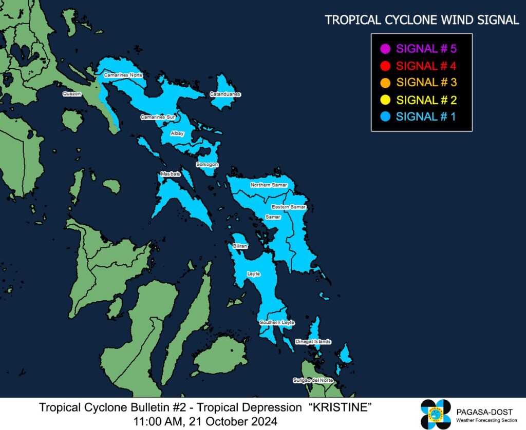
KRISTINE UPDATE: WIND SIGNALS AS OF 12 NOON

Pagasa image
Latest update on the wind signals in effect due to tropical depression Kristine.
Signal No. 1:
Luzon
Catanduanes, Masbate including Ticao Island and Burias Island, Camarines Sur, Albay, Sorsogon, Camarines Norte, and the eastern portion of Quezon. (Tagkawayan, Guinayangan, Buenavista, San Narciso, San Andres)
Visayas
Eastern Samar, Northern Samar, Samar, Leyte, Biliran, and Southern Leyte
Mindanao Dinagat Islands and Surigao del Norte including Siargao – Bucas Grande Group.
Kristine update: Tropical depression maintains strength over PH sea
Tropical Depression #KristinePH is currently moving west-southwestward at 30 km per hour with maximum sustained winds of up to 55 km per hour, Pagasa reports.

Kristine’s trough to bring rains in Cebu
Tropical Depression Kristine may not directly hit Cebu but it will bring rains here until Wednesday, October 23, the state weather bureau said.
The Mactan station of the Philippine Atmospheric Geophysical and Astronomical Services Administration (Pagasa) forecasted that the entire Cebu would experience wet weather beginning Monday, October 21 until Wednesday.
Read full story here.
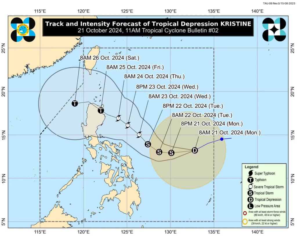
Pagasa: Tropical Depression Kristine enters PAR
The state weather bureau said in its latest update that Tropical Depression Kristine had entered the Philippine area of responsibility (PAR) early Monday morning.
The Philippine Atmospheric, Geophysical and Astronomical Services Administration (Pagasa) has also forecast that Kristine would develop into a typhoon before landfall over Northern Luzon towards the weekend.
Kristine was 1,050 kilometers east of southeastern Luzon as of 5 a.m., October 21, carrying maximum wind speeds of 55 kilometers per hour (kph) near the center with gustiness of up to 70 kph, said Pagasa.
Read full story here.

READ MORE:
Pagasa: Rains on Monday over most parts of PH due to LPA’s trough
TROPICAL CYCLONE WIND SIGNALS IN EFFECT
Kristine: Signal No. 1
Luzon
Catanduanes
Visayas
The northeastern portion of Northern Samar (Laoang, Palapag, Mapanas, Gamay, Catubig, Lapinig) and the northeastern portion of Eastern Samar (Jipapad, Arteche, San Policarpo, Oras)